You are here: Home > Network List > TA - USArray Transportable Network (new EarthScope stations) Stations List
> Station R56A Bull Pasture Mountain, McDowell, VA, USA > Earthquake Result Viewer
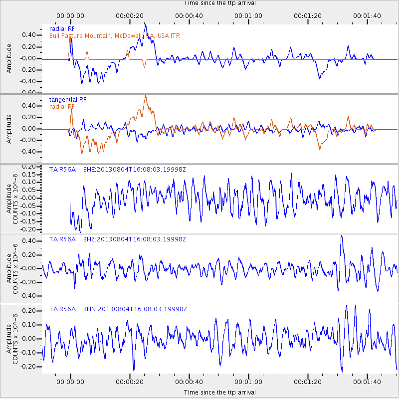
R56A Bull Pasture Mountain, McDowell, VA, USA - Earthquake Result Viewer
*The percent match for this event was below the threshold and hence no stack was calculated.
| Earthquake location: |
Sea Of Okhotsk |
| Earthquake latitude/longitude: |
47.0/145.2 |
| Earthquake time(UTC): |
2013/08/04 (216) 15:56:34 GMT |
| Earthquake Depth: |
375 km |
| Earthquake Magnitude: |
5.8 MW, 5.8 MW |
| Earthquake Catalog/Contributor: |
NEIC PDE/NEIC PDE-W |
|
| Network: |
TA USArray Transportable Network (new EarthScope stations) |
| Station: |
R56A Bull Pasture Mountain, McDowell, VA, USA |
| Lat/Lon: |
38.41 N/79.40 W |
| Elevation: |
902 m |
|
| Distance: |
86.1 deg |
| Az: |
33.583 deg |
| Baz: |
331.184 deg |
| Ray Param: |
$rayparam |
*The percent match for this event was below the threshold and hence was not used in the summary stack. |
|
| Radial Match: |
44.33051 % |
| Radial Bump: |
400 |
| Transverse Match: |
43.449375 % |
| Transverse Bump: |
400 |
| SOD ConfigId: |
589702 |
| Insert Time: |
2013-09-25 01:17:58.660 +0000 |
| GWidth: |
2.5 |
| Max Bumps: |
400 |
| Tol: |
0.001 |
|
Signal To Noise
| Channel | StoN | STA | LTA |
| TA:R56A: :BHZ:20130804T16:08:03.19998Z | 1.4036798 | 1.0378294E-7 | 7.3936334E-8 |
| TA:R56A: :BHN:20130804T16:08:03.19998Z | 1.0902613 | 8.811043E-8 | 8.081589E-8 |
| TA:R56A: :BHE:20130804T16:08:03.19998Z | 0.8375694 | 7.15132E-8 | 8.5381814E-8 |
| Arrivals |
| Ps | |
| PpPs | |
| PsPs/PpSs | |


