You are here: Home > Network List > IU - Global Seismograph Network (GSN - IRIS/USGS) Stations List
> Station JOHN Johnston Island, USA > Earthquake Result Viewer
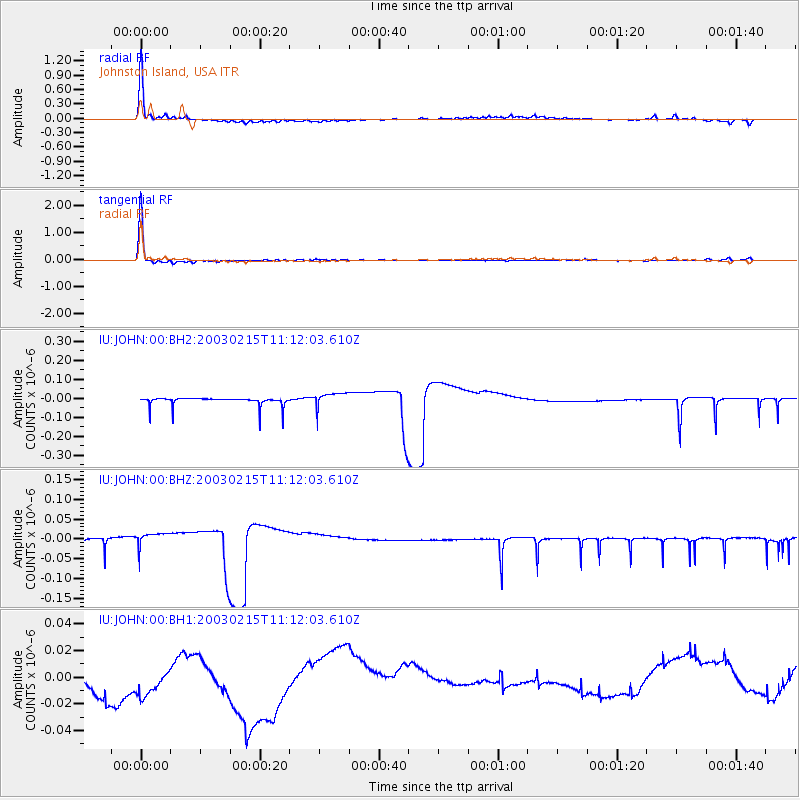
JOHN Johnston Island, USA - Earthquake Result Viewer
*The percent match for this event was below the threshold and hence no stack was calculated.
| Earthquake location: |
Samar, Philippines |
| Earthquake latitude/longitude: |
12.2/124.1 |
| Earthquake time(UTC): |
2003/02/15 (046) 11:01:59 GMT |
| Earthquake Depth: |
10 km |
| Earthquake Magnitude: |
5.8 MB, 6.2 MS, 6.3 MW, 6.2 MW |
| Earthquake Catalog/Contributor: |
WHDF/NEIC |
|
| Network: |
IU Global Seismograph Network (GSN - IRIS/USGS) |
| Station: |
JOHN Johnston Island, USA |
| Lat/Lon: |
16.73 N/169.53 W |
| Elevation: |
2.0 m |
|
| Distance: |
64.2 deg |
| Az: |
77.203 deg |
| Baz: |
275.649 deg |
| Ray Param: |
$rayparam |
*The percent match for this event was below the threshold and hence was not used in the summary stack. |
|
| Radial Match: |
87.24475 % |
| Radial Bump: |
305 |
| Transverse Match: |
98.50229 % |
| Transverse Bump: |
93 |
| SOD ConfigId: |
590571 |
| Insert Time: |
2013-09-25 01:18:02.314 +0000 |
| GWidth: |
2.5 |
| Max Bumps: |
400 |
| Tol: |
0.001 |
|
Signal To Noise
| Channel | StoN | STA | LTA |
| IU:JOHN:00:BHZ:20030215T11:12:03.610Z | 1.621178 | 1.8325514E-8 | 1.1303825E-8 |
| IU:JOHN:00:BH1:20030215T11:12:03.610Z | 1.3863465 | 2.709103E-8 | 1.9541313E-8 |
| IU:JOHN:00:BH2:20030215T11:12:03.610Z | 1.7795792 | 3.9917428E-8 | 2.2430823E-8 |
| Arrivals |
| Ps | |
| PpPs | |
| PsPs/PpSs | |


