You are here: Home > Network List > TA - USArray Transportable Network (new EarthScope stations) Stations List
> Station S44A Carbondale, IL, USA > Earthquake Result Viewer
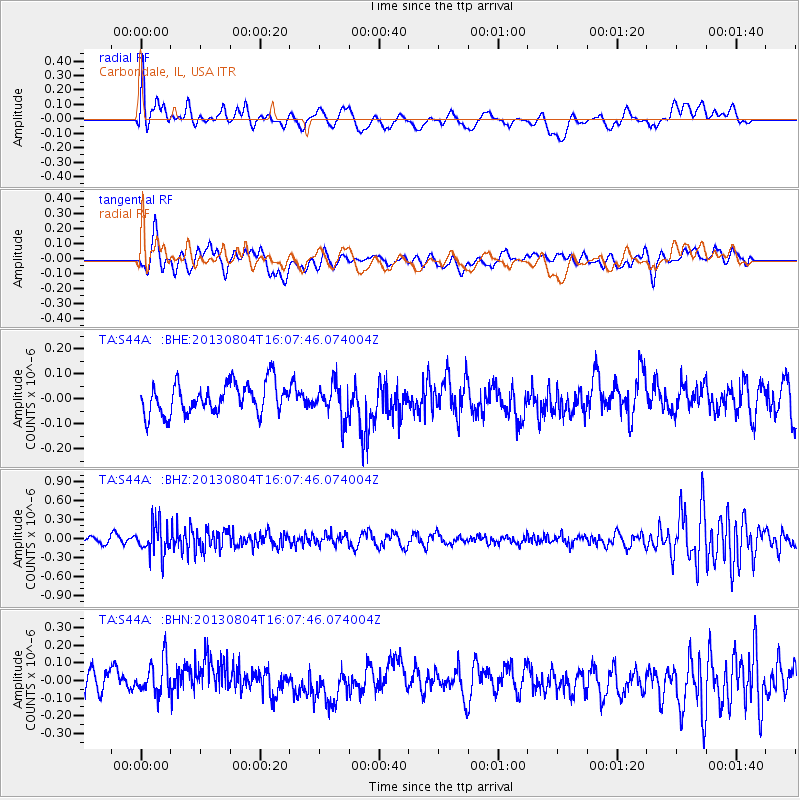
S44A Carbondale, IL, USA - Earthquake Result Viewer
*The percent match for this event was below the threshold and hence no stack was calculated.
| Earthquake location: |
Sea Of Okhotsk |
| Earthquake latitude/longitude: |
47.0/145.2 |
| Earthquake time(UTC): |
2013/08/04 (216) 15:56:34 GMT |
| Earthquake Depth: |
375 km |
| Earthquake Magnitude: |
5.8 MW, 5.8 MW |
| Earthquake Catalog/Contributor: |
NEIC PDE/NEIC PDE-W |
|
| Network: |
TA USArray Transportable Network (new EarthScope stations) |
| Station: |
S44A Carbondale, IL, USA |
| Lat/Lon: |
37.69 N/89.26 W |
| Elevation: |
155 m |
|
| Distance: |
82.6 deg |
| Az: |
40.616 deg |
| Baz: |
325.82 deg |
| Ray Param: |
$rayparam |
*The percent match for this event was below the threshold and hence was not used in the summary stack. |
|
| Radial Match: |
51.338566 % |
| Radial Bump: |
400 |
| Transverse Match: |
51.23383 % |
| Transverse Bump: |
400 |
| SOD ConfigId: |
589702 |
| Insert Time: |
2013-09-25 01:18:09.849 +0000 |
| GWidth: |
2.5 |
| Max Bumps: |
400 |
| Tol: |
0.001 |
|
Signal To Noise
| Channel | StoN | STA | LTA |
| TA:S44A: :BHZ:20130804T16:07:46.074004Z | 3.7245784 | 2.4660537E-7 | 6.6210276E-8 |
| TA:S44A: :BHN:20130804T16:07:46.074004Z | 1.3255134 | 1.0261697E-7 | 7.741677E-8 |
| TA:S44A: :BHE:20130804T16:07:46.074004Z | 1.1328623 | 6.845033E-8 | 6.0422465E-8 |
| Arrivals |
| Ps | |
| PpPs | |
| PsPs/PpSs | |


