You are here: Home > Network List > IU - Global Seismograph Network (GSN - IRIS/USGS) Stations List
> Station JOHN Johnston Island, USA > Earthquake Result Viewer
JOHN Johnston Island, USA - Earthquake Result Viewer

| Earthquake location: |
Hokkaido, Japan Region |
| Earthquake latitude/longitude: |
44.1/141.8 |
| Earthquake time(UTC): |
2003/02/19 (050) 05:01:40 GMT |
| Earthquake Depth: |
214 km |
| Earthquake Magnitude: |
5.9 MW |
| Earthquake Catalog/Contributor: |
NEIC PDE/NEIC PDE-M |
|
| Network: |
IU Global Seismograph Network (GSN - IRIS/USGS) |
| Station: |
JOHN Johnston Island, USA |
| Lat/Lon: |
16.73 N/169.53 W |
| Elevation: |
2.0 m |
|
| Distance: |
49.1 deg |
| Az: |
107.959 deg |
| Baz: |
314.384 deg |
| Ray Param: |
0.068098076 |
| Estimated Moho Depth: |
45.0 km |
| Estimated Crust Vp/Vs: |
1.84 |
| Assumed Crust Vp: |
4.24 km/s |
| Estimated Crust Vs: |
2.304 km/s |
| Estimated Crust Poisson's Ratio: |
0.29 |
|
| Radial Match: |
94.462234 % |
| Radial Bump: |
127 |
| Transverse Match: |
92.77058 % |
| Transverse Bump: |
259 |
| SOD ConfigId: |
590571 |
| Insert Time: |
2013-09-25 01:19:29.013 +0000 |
| GWidth: |
2.5 |
| Max Bumps: |
400 |
| Tol: |
0.001 |
|
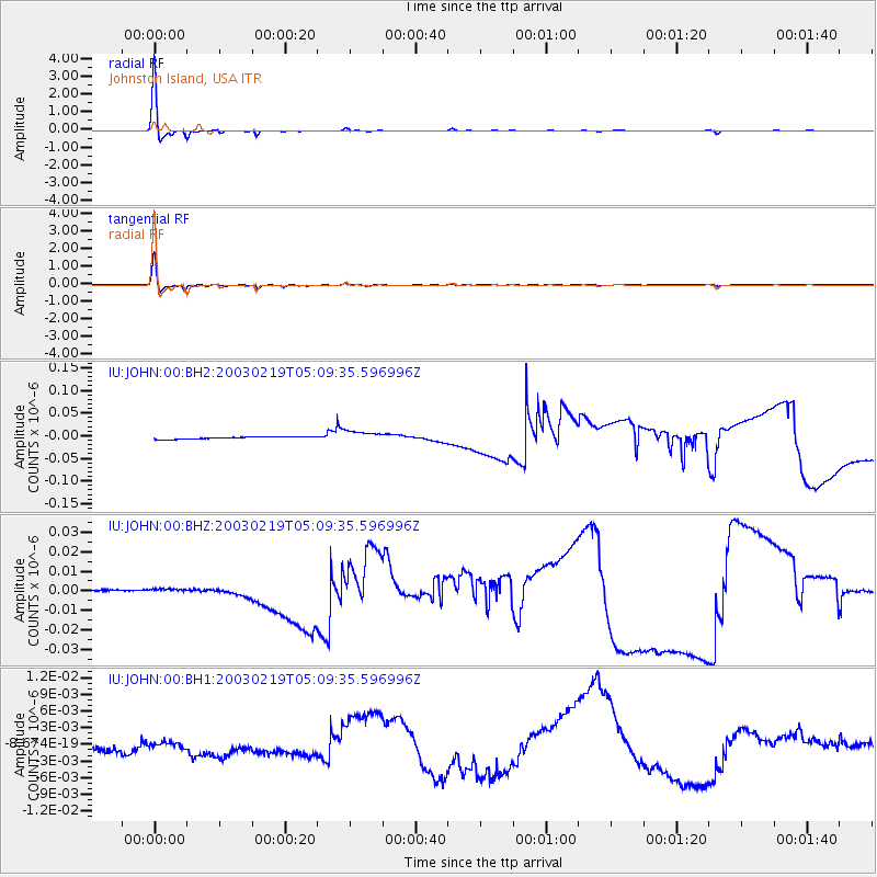
Signal To Noise
| Channel | StoN | STA | LTA |
| IU:JOHN:00:BHZ:20030219T05:09:35.596996Z | 2.4289424 | 1.0623044E-9 | 4.3735263E-10 |
| IU:JOHN:00:BH1:20030219T05:09:35.596996Z | 0.5894792 | 8.750184E-10 | 1.4843924E-9 |
| IU:JOHN:00:BH2:20030219T05:09:35.596996Z | 4.5618644 | 1.18895205E-8 | 2.6062854E-9 |
| Arrivals |
| Ps | 9.1 SECOND |
| PpPs | 29 SECOND |
| PsPs/PpSs | 39 SECOND |


