You are here: Home > Network List > US - United States National Seismic Network Stations List
> Station DGMT Dagmar, Montana, USA > Earthquake Result Viewer
DGMT Dagmar, Montana, USA - Earthquake Result Viewer
*The percent match for this event was below the threshold and hence no stack was calculated.
| Earthquake location: |
Sea Of Okhotsk |
| Earthquake latitude/longitude: |
47.0/145.2 |
| Earthquake time(UTC): |
2013/08/04 (216) 15:56:34 GMT |
| Earthquake Depth: |
375 km |
| Earthquake Magnitude: |
5.8 MW, 5.8 MW |
| Earthquake Catalog/Contributor: |
NEIC PDE/NEIC PDE-W |
|
| Network: |
US United States National Seismic Network |
| Station: |
DGMT Dagmar, Montana, USA |
| Lat/Lon: |
48.47 N/104.20 W |
| Elevation: |
0.0 m |
|
| Distance: |
67.4 deg |
| Az: |
42.431 deg |
| Baz: |
316.048 deg |
| Ray Param: |
$rayparam |
*The percent match for this event was below the threshold and hence was not used in the summary stack. |
|
| Radial Match: |
48.92274 % |
| Radial Bump: |
400 |
| Transverse Match: |
47.5577 % |
| Transverse Bump: |
400 |
| SOD ConfigId: |
589702 |
| Insert Time: |
2013-09-25 01:21:56.796 +0000 |
| GWidth: |
2.5 |
| Max Bumps: |
400 |
| Tol: |
0.001 |
|
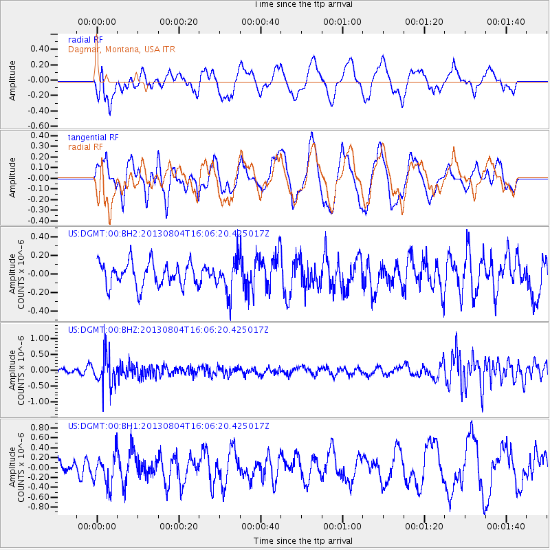
Signal To Noise
| Channel | StoN | STA | LTA |
| US:DGMT:00:BHZ:20130804T16:06:20.425017Z | 9.02909 | 5.0679404E-7 | 5.6129032E-8 |
| US:DGMT:00:BH1:20130804T16:06:20.425017Z | 2.4168813 | 3.2968768E-7 | 1.3641038E-7 |
| US:DGMT:00:BH2:20130804T16:06:20.425017Z | 1.47369 | 1.8930251E-7 | 1.2845476E-7 |
| Arrivals |
| Ps | |
| PpPs | |
| PsPs/PpSs | |


