You are here: Home > Network List > US - United States National Seismic Network Stations List
> Station HAWA Hanford, Washington, USA > Earthquake Result Viewer
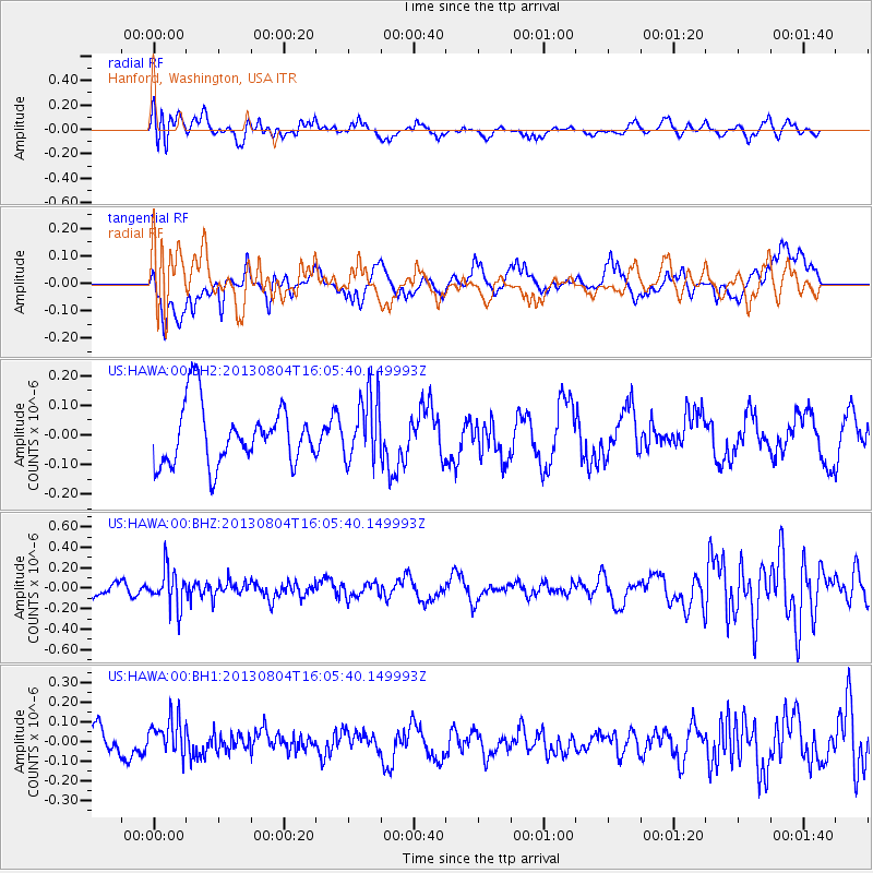
HAWA Hanford, Washington, USA - Earthquake Result Viewer
*The percent match for this event was below the threshold and hence no stack was calculated.
| Earthquake location: |
Sea Of Okhotsk |
| Earthquake latitude/longitude: |
47.0/145.2 |
| Earthquake time(UTC): |
2013/08/04 (216) 15:56:34 GMT |
| Earthquake Depth: |
375 km |
| Earthquake Magnitude: |
5.8 MW, 5.8 MW |
| Earthquake Catalog/Contributor: |
NEIC PDE/NEIC PDE-W |
|
| Network: |
US United States National Seismic Network |
| Station: |
HAWA Hanford, Washington, USA |
| Lat/Lon: |
46.39 N/119.53 W |
| Elevation: |
364 m |
|
| Distance: |
61.1 deg |
| Az: |
51.908 deg |
| Baz: |
308.881 deg |
| Ray Param: |
$rayparam |
*The percent match for this event was below the threshold and hence was not used in the summary stack. |
|
| Radial Match: |
64.68585 % |
| Radial Bump: |
400 |
| Transverse Match: |
53.20387 % |
| Transverse Bump: |
400 |
| SOD ConfigId: |
589702 |
| Insert Time: |
2013-09-25 01:22:17.550 +0000 |
| GWidth: |
2.5 |
| Max Bumps: |
400 |
| Tol: |
0.001 |
|
Signal To Noise
| Channel | StoN | STA | LTA |
| US:HAWA:00:BHZ:20130804T16:05:40.149993Z | 1.7917169 | 1.8231998E-7 | 1.0175713E-7 |
| US:HAWA:00:BH1:20130804T16:05:40.149993Z | 1.3116857 | 9.767779E-8 | 7.446738E-8 |
| US:HAWA:00:BH2:20130804T16:05:40.149993Z | 1.1131998 | 1.1087891E-7 | 9.960379E-8 |
| Arrivals |
| Ps | |
| PpPs | |
| PsPs/PpSs | |


