You are here: Home > Network List > IU - Global Seismograph Network (GSN - IRIS/USGS) Stations List
> Station JOHN Johnston Island, USA > Earthquake Result Viewer
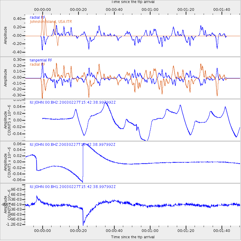
JOHN Johnston Island, USA - Earthquake Result Viewer
*The percent match for this event was below the threshold and hence no stack was calculated.
| Earthquake location: |
Alaska Peninsula |
| Earthquake latitude/longitude: |
58.7/-156.9 |
| Earthquake time(UTC): |
2003/02/27 (058) 15:35:30 GMT |
| Earthquake Depth: |
202 km |
| Earthquake Magnitude: |
5.5 MW |
| Earthquake Catalog/Contributor: |
NEIC PDE/NEIC PDE-M |
|
| Network: |
IU Global Seismograph Network (GSN - IRIS/USGS) |
| Station: |
JOHN Johnston Island, USA |
| Lat/Lon: |
16.73 N/169.53 W |
| Elevation: |
2.0 m |
|
| Distance: |
42.9 deg |
| Az: |
197.958 deg |
| Baz: |
9.669 deg |
| Ray Param: |
$rayparam |
*The percent match for this event was below the threshold and hence was not used in the summary stack. |
|
| Radial Match: |
82.183136 % |
| Radial Bump: |
361 |
| Transverse Match: |
81.921814 % |
| Transverse Bump: |
350 |
| SOD ConfigId: |
590571 |
| Insert Time: |
2013-09-25 01:22:32.717 +0000 |
| GWidth: |
2.5 |
| Max Bumps: |
400 |
| Tol: |
0.001 |
|
Signal To Noise
| Channel | StoN | STA | LTA |
| IU:JOHN:00:BHZ:20030227T15:42:38.997992Z | 6.1307006 | 3.3885577E-8 | 5.5271947E-9 |
| IU:JOHN:00:BH1:20030227T15:42:38.997992Z | 0.45705712 | 6.1437067E-10 | 1.344188E-9 |
| IU:JOHN:00:BH2:20030227T15:42:38.997992Z | 1.7893006 | 2.7965536E-8 | 1.5629311E-8 |
| Arrivals |
| Ps | |
| PpPs | |
| PsPs/PpSs | |


