You are here: Home > Network List > IU - Global Seismograph Network (GSN - IRIS/USGS) Stations List
> Station RSSD Black Hills, South Dakota, USA > Earthquake Result Viewer
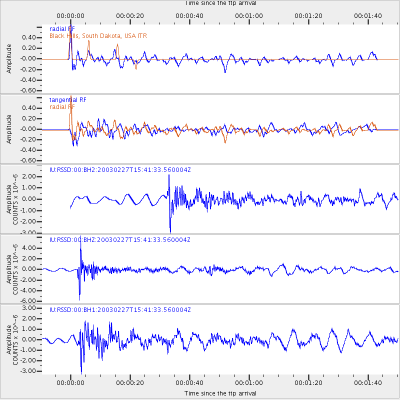
RSSD Black Hills, South Dakota, USA - Earthquake Result Viewer
*The percent match for this event was below the threshold and hence no stack was calculated.
| Earthquake location: |
Alaska Peninsula |
| Earthquake latitude/longitude: |
58.7/-156.9 |
| Earthquake time(UTC): |
2003/02/27 (058) 15:35:30 GMT |
| Earthquake Depth: |
202 km |
| Earthquake Magnitude: |
5.5 MW |
| Earthquake Catalog/Contributor: |
NEIC PDE/NEIC PDE-M |
|
| Network: |
IU Global Seismograph Network (GSN - IRIS/USGS) |
| Station: |
RSSD Black Hills, South Dakota, USA |
| Lat/Lon: |
44.12 N/104.04 W |
| Elevation: |
2060 m |
|
| Distance: |
35.0 deg |
| Az: |
90.901 deg |
| Baz: |
313.559 deg |
| Ray Param: |
$rayparam |
*The percent match for this event was below the threshold and hence was not used in the summary stack. |
|
| Radial Match: |
46.131 % |
| Radial Bump: |
400 |
| Transverse Match: |
61.66643 % |
| Transverse Bump: |
400 |
| SOD ConfigId: |
590571 |
| Insert Time: |
2013-09-25 01:22:37.381 +0000 |
| GWidth: |
2.5 |
| Max Bumps: |
400 |
| Tol: |
0.001 |
|
Signal To Noise
| Channel | StoN | STA | LTA |
| IU:RSSD:00:BHZ:20030227T15:41:33.560004Z | 6.621653 | 1.604516E-6 | 2.4231352E-7 |
| IU:RSSD:00:BH1:20030227T15:41:33.560004Z | 3.3849256 | 8.641892E-7 | 2.5530522E-7 |
| IU:RSSD:00:BH2:20030227T15:41:33.560004Z | 3.3777015 | 8.691146E-7 | 2.5730947E-7 |
| Arrivals |
| Ps | |
| PpPs | |
| PsPs/PpSs | |


