You are here: Home > Network List > US - United States National Seismic Network Stations List
> Station MIAR Mount Ida, Arkansas, USA > Earthquake Result Viewer
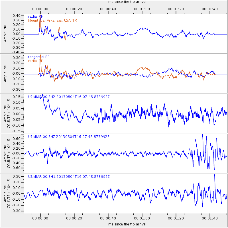
MIAR Mount Ida, Arkansas, USA - Earthquake Result Viewer
*The percent match for this event was below the threshold and hence no stack was calculated.
| Earthquake location: |
Sea Of Okhotsk |
| Earthquake latitude/longitude: |
47.0/145.2 |
| Earthquake time(UTC): |
2013/08/04 (216) 15:56:34 GMT |
| Earthquake Depth: |
375 km |
| Earthquake Magnitude: |
5.8 MW, 5.8 MW |
| Earthquake Catalog/Contributor: |
NEIC PDE/NEIC PDE-W |
|
| Network: |
US United States National Seismic Network |
| Station: |
MIAR Mount Ida, Arkansas, USA |
| Lat/Lon: |
34.55 N/93.58 W |
| Elevation: |
207 m |
|
| Distance: |
83.2 deg |
| Az: |
45.321 deg |
| Baz: |
323.863 deg |
| Ray Param: |
$rayparam |
*The percent match for this event was below the threshold and hence was not used in the summary stack. |
|
| Radial Match: |
52.259544 % |
| Radial Bump: |
400 |
| Transverse Match: |
46.221546 % |
| Transverse Bump: |
400 |
| SOD ConfigId: |
589702 |
| Insert Time: |
2013-09-25 01:22:40.700 +0000 |
| GWidth: |
2.5 |
| Max Bumps: |
400 |
| Tol: |
0.001 |
|
Signal To Noise
| Channel | StoN | STA | LTA |
| US:MIAR:00:BHZ:20130804T16:07:48.873992Z | 2.5762773 | 1.2183118E-7 | 4.728962E-8 |
| US:MIAR:00:BH1:20130804T16:07:48.873992Z | 1.4012967 | 6.126519E-8 | 4.3720355E-8 |
| US:MIAR:00:BH2:20130804T16:07:48.873992Z | 0.83202904 | 5.104297E-8 | 6.134758E-8 |
| Arrivals |
| Ps | |
| PpPs | |
| PsPs/PpSs | |


