You are here: Home > Network List > US - United States National Seismic Network Stations List
> Station WMOK Wichita Mountains, Oklahoma, USA > Earthquake Result Viewer
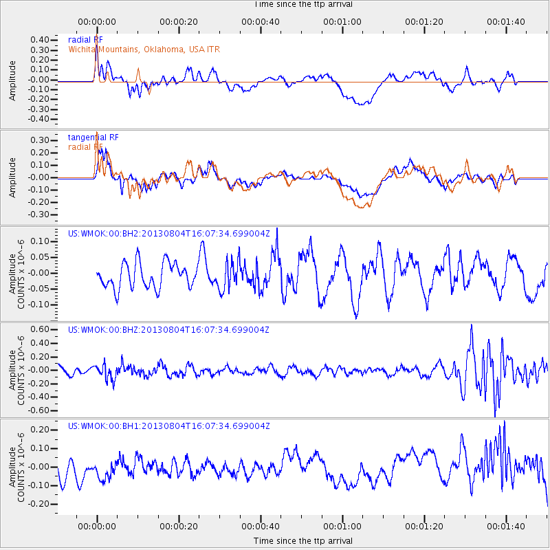
WMOK Wichita Mountains, Oklahoma, USA - Earthquake Result Viewer
*The percent match for this event was below the threshold and hence no stack was calculated.
| Earthquake location: |
Sea Of Okhotsk |
| Earthquake latitude/longitude: |
47.0/145.2 |
| Earthquake time(UTC): |
2013/08/04 (216) 15:56:34 GMT |
| Earthquake Depth: |
375 km |
| Earthquake Magnitude: |
5.8 MW, 5.8 MW |
| Earthquake Catalog/Contributor: |
NEIC PDE/NEIC PDE-W |
|
| Network: |
US United States National Seismic Network |
| Station: |
WMOK Wichita Mountains, Oklahoma, USA |
| Lat/Lon: |
34.74 N/98.78 W |
| Elevation: |
486 m |
|
| Distance: |
80.4 deg |
| Az: |
48.648 deg |
| Baz: |
321.391 deg |
| Ray Param: |
$rayparam |
*The percent match for this event was below the threshold and hence was not used in the summary stack. |
|
| Radial Match: |
38.90854 % |
| Radial Bump: |
400 |
| Transverse Match: |
59.847755 % |
| Transverse Bump: |
400 |
| SOD ConfigId: |
589702 |
| Insert Time: |
2013-09-25 01:23:09.610 +0000 |
| GWidth: |
2.5 |
| Max Bumps: |
400 |
| Tol: |
0.001 |
|
Signal To Noise
| Channel | StoN | STA | LTA |
| US:WMOK:00:BHZ:20130804T16:07:34.699004Z | 2.2366407 | 1.0607005E-7 | 4.742382E-8 |
| US:WMOK:00:BH1:20130804T16:07:34.699004Z | 0.95496374 | 7.9491585E-8 | 8.324042E-8 |
| US:WMOK:00:BH2:20130804T16:07:34.699004Z | 1.1561924 | 4.4934243E-8 | 3.8863984E-8 |
| Arrivals |
| Ps | |
| PpPs | |
| PsPs/PpSs | |


