You are here: Home > Network List > CN - Canadian National Seismograph Network Stations List
> Station ULM LAC DU BONNET, MB, CANADA > Earthquake Result Viewer
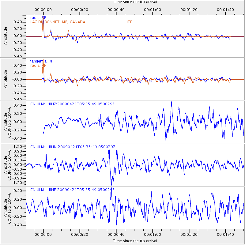
ULM LAC DU BONNET, MB, CANADA - Earthquake Result Viewer
*The percent match for this event was below the threshold and hence no stack was calculated.
| Earthquake location: |
Kuril Islands |
| Earthquake latitude/longitude: |
50.8/155.0 |
| Earthquake time(UTC): |
2009/04/21 (111) 05:26:11 GMT |
| Earthquake Depth: |
152 km |
| Earthquake Magnitude: |
6.0 MB, 6.2 MW, 6.2 MW |
| Earthquake Catalog/Contributor: |
WHDF/NEIC |
|
| Network: |
CN Canadian National Seismograph Network |
| Station: |
ULM LAC DU BONNET, MB, CANADA |
| Lat/Lon: |
50.25 N/95.87 W |
| Elevation: |
251 m |
|
| Distance: |
62.6 deg |
| Az: |
43.075 deg |
| Baz: |
317.576 deg |
| Ray Param: |
$rayparam |
*The percent match for this event was below the threshold and hence was not used in the summary stack. |
|
| Radial Match: |
79.42635 % |
| Radial Bump: |
400 |
| Transverse Match: |
55.809525 % |
| Transverse Bump: |
400 |
| SOD ConfigId: |
2760 |
| Insert Time: |
2010-02-27 07:35:54.787 +0000 |
| GWidth: |
2.5 |
| Max Bumps: |
400 |
| Tol: |
0.001 |
|
Signal To Noise
| Channel | StoN | STA | LTA |
| CN:ULM: :BHN:20090421T05:35:49.050029Z | 2.5416253 | 2.3149116E-7 | 9.107997E-8 |
| CN:ULM: :BHE:20090421T05:35:49.050029Z | 1.3775105 | 1.2922375E-7 | 9.3809625E-8 |
| CN:ULM: :BHZ:20090421T05:35:49.050029Z | 0.8928306 | 7.436612E-8 | 8.329253E-8 |
| Arrivals |
| Ps | |
| PpPs | |
| PsPs/PpSs | |


