You are here: Home > Network List > UW - Pacific Northwest Regional Seismic Network Stations List
> Station HOOD Mt Hood Meadows, OR CREST BB SMO > Earthquake Result Viewer
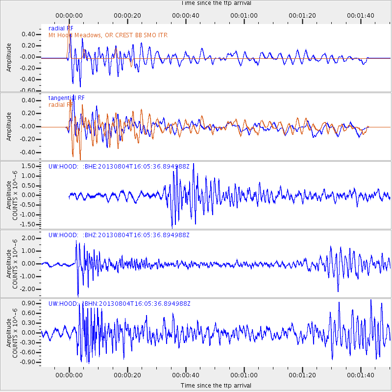
HOOD Mt Hood Meadows, OR CREST BB SMO - Earthquake Result Viewer
*The percent match for this event was below the threshold and hence no stack was calculated.
| Earthquake location: |
Sea Of Okhotsk |
| Earthquake latitude/longitude: |
47.0/145.2 |
| Earthquake time(UTC): |
2013/08/04 (216) 15:56:34 GMT |
| Earthquake Depth: |
375 km |
| Earthquake Magnitude: |
5.8 MW, 5.8 MW |
| Earthquake Catalog/Contributor: |
NEIC PDE/NEIC PDE-W |
|
| Network: |
UW Pacific Northwest Regional Seismic Network |
| Station: |
HOOD Mt Hood Meadows, OR CREST BB SMO |
| Lat/Lon: |
45.32 N/121.65 W |
| Elevation: |
1520 m |
|
| Distance: |
60.6 deg |
| Az: |
53.925 deg |
| Baz: |
308.345 deg |
| Ray Param: |
$rayparam |
*The percent match for this event was below the threshold and hence was not used in the summary stack. |
|
| Radial Match: |
76.35589 % |
| Radial Bump: |
400 |
| Transverse Match: |
73.211655 % |
| Transverse Bump: |
400 |
| SOD ConfigId: |
589702 |
| Insert Time: |
2013-09-25 01:24:27.048 +0000 |
| GWidth: |
2.5 |
| Max Bumps: |
400 |
| Tol: |
0.001 |
|
Signal To Noise
| Channel | StoN | STA | LTA |
| UW:HOOD: :BHZ:20130804T16:05:36.894988Z | 6.9403505 | 8.0262504E-7 | 1.1564619E-7 |
| UW:HOOD: :BHN:20130804T16:05:36.894988Z | 3.5505347 | 3.9444828E-7 | 1.1109546E-7 |
| UW:HOOD: :BHE:20130804T16:05:36.894988Z | 1.8209642 | 2.4976686E-7 | 1.3716188E-7 |
| Arrivals |
| Ps | |
| PpPs | |
| PsPs/PpSs | |


