You are here: Home > Network List > TA - USArray Transportable Network (new EarthScope stations) Stations List
> Station MSTX Muleshoe, TX, USA > Earthquake Result Viewer
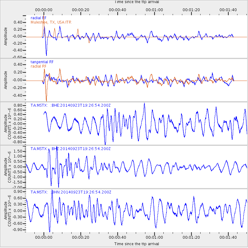
MSTX Muleshoe, TX, USA - Earthquake Result Viewer
*The percent match for this event was below the threshold and hence no stack was calculated.
| Earthquake location: |
Reykjanes Ridge |
| Earthquake latitude/longitude: |
53.1/-35.1 |
| Earthquake time(UTC): |
2014/09/23 (266) 19:18:25 GMT |
| Earthquake Depth: |
7.2 km |
| Earthquake Magnitude: |
5.4 MW |
| Earthquake Catalog/Contributor: |
ISC/ISC |
|
| Network: |
TA USArray Transportable Network (new EarthScope stations) |
| Station: |
MSTX Muleshoe, TX, USA |
| Lat/Lon: |
33.97 N/102.77 W |
| Elevation: |
1167 m |
|
| Distance: |
50.6 deg |
| Az: |
276.166 deg |
| Baz: |
46.1 deg |
| Ray Param: |
$rayparam |
*The percent match for this event was below the threshold and hence was not used in the summary stack. |
|
| Radial Match: |
71.18875 % |
| Radial Bump: |
400 |
| Transverse Match: |
62.03571 % |
| Transverse Bump: |
400 |
| SOD ConfigId: |
3390531 |
| Insert Time: |
2019-04-14 04:49:49.635 +0000 |
| GWidth: |
2.5 |
| Max Bumps: |
400 |
| Tol: |
0.001 |
|
Signal To Noise
| Channel | StoN | STA | LTA |
| TA:MSTX: :BHZ:20140923T19:26:54.200Z | 2.7793639 | 8.598518E-7 | 3.0937E-7 |
| TA:MSTX: :BHN:20140923T19:26:54.200Z | 1.0818971 | 4.9344834E-7 | 4.5609545E-7 |
| TA:MSTX: :BHE:20140923T19:26:54.200Z | 1.8555807 | 4.469391E-7 | 2.4086214E-7 |
| Arrivals |
| Ps | |
| PpPs | |
| PsPs/PpSs | |


