You are here: Home > Network List > TA - USArray Transportable Network (new EarthScope stations) Stations List
> Station O03E Paynes Creek, CA, USA > Earthquake Result Viewer
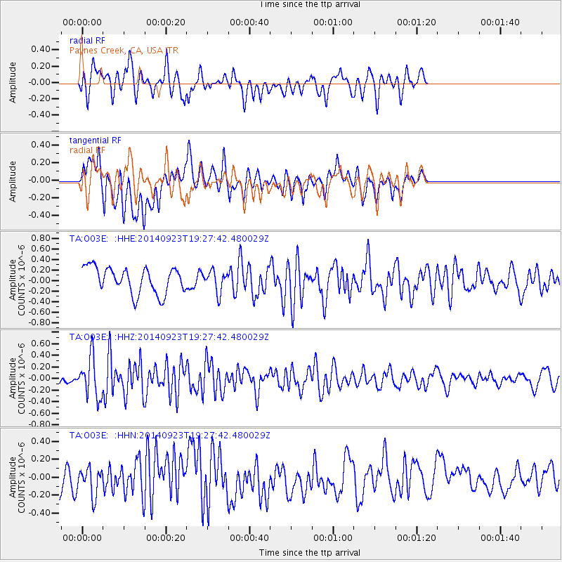
O03E Paynes Creek, CA, USA - Earthquake Result Viewer
*The percent match for this event was below the threshold and hence no stack was calculated.
| Earthquake location: |
Reykjanes Ridge |
| Earthquake latitude/longitude: |
53.1/-35.1 |
| Earthquake time(UTC): |
2014/09/23 (266) 19:18:25 GMT |
| Earthquake Depth: |
7.2 km |
| Earthquake Magnitude: |
5.4 MW |
| Earthquake Catalog/Contributor: |
ISC/ISC |
|
| Network: |
TA USArray Transportable Network (new EarthScope stations) |
| Station: |
O03E Paynes Creek, CA, USA |
| Lat/Lon: |
40.29 N/121.80 W |
| Elevation: |
967 m |
|
| Distance: |
57.3 deg |
| Az: |
294.809 deg |
| Baz: |
45.627 deg |
| Ray Param: |
$rayparam |
*The percent match for this event was below the threshold and hence was not used in the summary stack. |
|
| Radial Match: |
55.66341 % |
| Radial Bump: |
400 |
| Transverse Match: |
51.594154 % |
| Transverse Bump: |
400 |
| SOD ConfigId: |
3390531 |
| Insert Time: |
2019-04-14 04:49:52.386 +0000 |
| GWidth: |
2.5 |
| Max Bumps: |
400 |
| Tol: |
0.001 |
|
Signal To Noise
| Channel | StoN | STA | LTA |
| TA:O03E: :HHZ:20140923T19:27:42.480029Z | 3.222595 | 3.4865218E-7 | 1.0818988E-7 |
| TA:O03E: :HHN:20140923T19:27:42.480029Z | 1.0449786 | 1.5421313E-7 | 1.4757539E-7 |
| TA:O03E: :HHE:20140923T19:27:42.480029Z | 0.8457682 | 2.074209E-7 | 2.4524556E-7 |
| Arrivals |
| Ps | |
| PpPs | |
| PsPs/PpSs | |


