You are here: Home > Network List > TA - USArray Transportable Network (new EarthScope stations) Stations List
> Station W57A Gilead, NC, USA > Earthquake Result Viewer
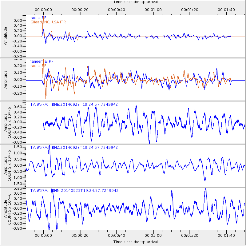
W57A Gilead, NC, USA - Earthquake Result Viewer
*The percent match for this event was below the threshold and hence no stack was calculated.
| Earthquake location: |
Reykjanes Ridge |
| Earthquake latitude/longitude: |
53.1/-35.1 |
| Earthquake time(UTC): |
2014/09/23 (266) 19:18:25 GMT |
| Earthquake Depth: |
7.2 km |
| Earthquake Magnitude: |
5.4 MW |
| Earthquake Catalog/Contributor: |
ISC/ISC |
|
| Network: |
TA USArray Transportable Network (new EarthScope stations) |
| Station: |
W57A Gilead, NC, USA |
| Lat/Lon: |
35.15 N/79.99 W |
| Elevation: |
85 m |
|
| Distance: |
36.2 deg |
| Az: |
258.462 deg |
| Baz: |
46.07 deg |
| Ray Param: |
$rayparam |
*The percent match for this event was below the threshold and hence was not used in the summary stack. |
|
| Radial Match: |
62.609077 % |
| Radial Bump: |
400 |
| Transverse Match: |
58.018726 % |
| Transverse Bump: |
400 |
| SOD ConfigId: |
3390531 |
| Insert Time: |
2019-04-14 04:50:19.663 +0000 |
| GWidth: |
2.5 |
| Max Bumps: |
400 |
| Tol: |
0.001 |
|
Signal To Noise
| Channel | StoN | STA | LTA |
| TA:W57A: :BHZ:20140923T19:24:57.724994Z | 3.4510186 | 7.5636854E-7 | 2.1917255E-7 |
| TA:W57A: :BHN:20140923T19:24:57.724994Z | 2.1378818 | 4.6115306E-7 | 2.157056E-7 |
| TA:W57A: :BHE:20140923T19:24:57.724994Z | 1.4233608 | 3.2188333E-7 | 2.2614317E-7 |
| Arrivals |
| Ps | |
| PpPs | |
| PsPs/PpSs | |


