You are here: Home > Network List > CI - Caltech Regional Seismic Network Stations List
> Station LRL Laurel Mtn Radio Fac, Ridgecrest, CA, USA > Earthquake Result Viewer
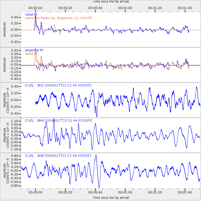
LRL Laurel Mtn Radio Fac, Ridgecrest, CA, USA - Earthquake Result Viewer
*The percent match for this event was below the threshold and hence no stack was calculated.
| Earthquake location: |
Easter Island Region |
| Earthquake latitude/longitude: |
-29.1/-112.3 |
| Earthquake time(UTC): |
2009/09/17 (260) 23:21:38 GMT |
| Earthquake Depth: |
10 km |
| Earthquake Magnitude: |
5.7 MB, 6.0 MS, 6.2 MW, 6.2 MW |
| Earthquake Catalog/Contributor: |
WHDF/NEIC |
|
| Network: |
CI Caltech Regional Seismic Network |
| Station: |
LRL Laurel Mtn Radio Fac, Ridgecrest, CA, USA |
| Lat/Lon: |
35.48 N/117.68 W |
| Elevation: |
1340 m |
|
| Distance: |
64.5 deg |
| Az: |
355.104 deg |
| Baz: |
174.751 deg |
| Ray Param: |
$rayparam |
*The percent match for this event was below the threshold and hence was not used in the summary stack. |
|
| Radial Match: |
73.233765 % |
| Radial Bump: |
400 |
| Transverse Match: |
60.093346 % |
| Transverse Bump: |
346 |
| SOD ConfigId: |
2622 |
| Insert Time: |
2010-02-25 20:43:31.902 +0000 |
| GWidth: |
2.5 |
| Max Bumps: |
400 |
| Tol: |
0.001 |
|
Signal To Noise
| Channel | StoN | STA | LTA |
| CI:LRL: :BHN:20090917T23:31:44.025005Z | 2.1885767 | 3.961395E-7 | 1.8100327E-7 |
| CI:LRL: :BHE:20090917T23:31:44.025005Z | 1.9273965 | 2.530396E-7 | 1.3128569E-7 |
| CI:LRL: :BHZ:20090917T23:31:44.025005Z | 0.8840346 | 1.1449785E-7 | 1.2951739E-7 |
| Arrivals |
| Ps | |
| PpPs | |
| PsPs/PpSs | |


