You are here: Home > Network List > TA - USArray Transportable Network (new EarthScope stations) Stations List
> Station Z41A Richland Creek Farm, El Dorado, AR, USA > Earthquake Result Viewer
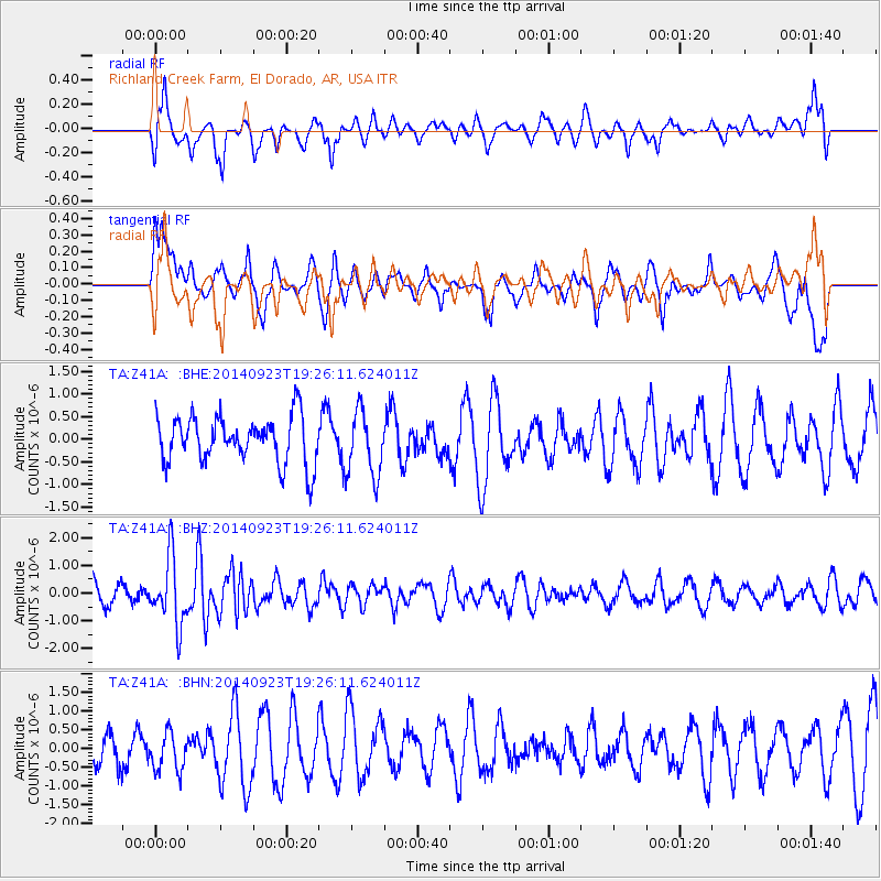
Z41A Richland Creek Farm, El Dorado, AR, USA - Earthquake Result Viewer
*The percent match for this event was below the threshold and hence no stack was calculated.
| Earthquake location: |
Reykjanes Ridge |
| Earthquake latitude/longitude: |
53.1/-35.1 |
| Earthquake time(UTC): |
2014/09/23 (266) 19:18:25 GMT |
| Earthquake Depth: |
7.2 km |
| Earthquake Magnitude: |
5.4 MW |
| Earthquake Catalog/Contributor: |
ISC/ISC |
|
| Network: |
TA USArray Transportable Network (new EarthScope stations) |
| Station: |
Z41A Richland Creek Farm, El Dorado, AR, USA |
| Lat/Lon: |
33.26 N/92.80 W |
| Elevation: |
62 m |
|
| Distance: |
45.1 deg |
| Az: |
267.694 deg |
| Baz: |
45.911 deg |
| Ray Param: |
$rayparam |
*The percent match for this event was below the threshold and hence was not used in the summary stack. |
|
| Radial Match: |
63.657795 % |
| Radial Bump: |
400 |
| Transverse Match: |
51.973442 % |
| Transverse Bump: |
400 |
| SOD ConfigId: |
3390531 |
| Insert Time: |
2019-04-14 04:50:27.422 +0000 |
| GWidth: |
2.5 |
| Max Bumps: |
400 |
| Tol: |
0.001 |
|
Signal To Noise
| Channel | StoN | STA | LTA |
| TA:Z41A: :BHZ:20140923T19:26:11.624011Z | 2.8397028 | 1.2221221E-6 | 4.3036974E-7 |
| TA:Z41A: :BHN:20140923T19:26:11.624011Z | 1.025062 | 5.23045E-7 | 5.1025694E-7 |
| TA:Z41A: :BHE:20140923T19:26:11.624011Z | 1.4178332 | 7.2517565E-7 | 5.1146753E-7 |
| Arrivals |
| Ps | |
| PpPs | |
| PsPs/PpSs | |


