You are here: Home > Network List > IU - Global Seismograph Network (GSN - IRIS/USGS) Stations List
> Station JOHN Johnston Island, USA > Earthquake Result Viewer
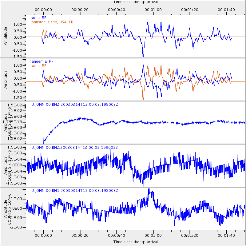
JOHN Johnston Island, USA - Earthquake Result Viewer
*The percent match for this event was below the threshold and hence no stack was calculated.
| Earthquake location: |
Tonga Islands |
| Earthquake latitude/longitude: |
-17.4/-175.2 |
| Earthquake time(UTC): |
2003/03/14 (073) 12:54:12 GMT |
| Earthquake Depth: |
275 km |
| Earthquake Magnitude: |
5.7 MB, 6.4 MW, 6.4 MW |
| Earthquake Catalog/Contributor: |
WHDF/NEIC |
|
| Network: |
IU Global Seismograph Network (GSN - IRIS/USGS) |
| Station: |
JOHN Johnston Island, USA |
| Lat/Lon: |
16.73 N/169.53 W |
| Elevation: |
2.0 m |
|
| Distance: |
34.4 deg |
| Az: |
9.622 deg |
| Baz: |
189.586 deg |
| Ray Param: |
$rayparam |
*The percent match for this event was below the threshold and hence was not used in the summary stack. |
|
| Radial Match: |
42.021572 % |
| Radial Bump: |
381 |
| Transverse Match: |
71.03877 % |
| Transverse Bump: |
400 |
| SOD ConfigId: |
590571 |
| Insert Time: |
2013-09-25 01:30:10.689 +0000 |
| GWidth: |
2.5 |
| Max Bumps: |
400 |
| Tol: |
0.001 |
|
Signal To Noise
| Channel | StoN | STA | LTA |
| IU:JOHN:00:BHZ:20030314T13:00:03.198003Z | 0.80932057 | 2.9941657E-10 | 3.6996042E-10 |
| IU:JOHN:00:BH1:20030314T13:00:03.198003Z | 0.7461757 | 5.9880806E-10 | 8.0250273E-10 |
| IU:JOHN:00:BH2:20030314T13:00:03.198003Z | 0.14583878 | 8.7720303E-10 | 6.014882E-9 |
| Arrivals |
| Ps | |
| PpPs | |
| PsPs/PpSs | |


