You are here: Home > Network List > US - United States National Seismic Network Stations List
> Station AMTX Amarillo, Texas, USA > Earthquake Result Viewer
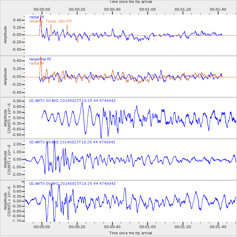
AMTX Amarillo, Texas, USA - Earthquake Result Viewer
*The percent match for this event was below the threshold and hence no stack was calculated.
| Earthquake location: |
Reykjanes Ridge |
| Earthquake latitude/longitude: |
53.1/-35.1 |
| Earthquake time(UTC): |
2014/09/23 (266) 19:18:25 GMT |
| Earthquake Depth: |
7.2 km |
| Earthquake Magnitude: |
5.4 MW |
| Earthquake Catalog/Contributor: |
ISC/ISC |
|
| Network: |
US United States National Seismic Network |
| Station: |
AMTX Amarillo, Texas, USA |
| Lat/Lon: |
34.53 N/101.41 W |
| Elevation: |
1010 m |
|
| Distance: |
49.4 deg |
| Az: |
275.676 deg |
| Baz: |
46.55 deg |
| Ray Param: |
$rayparam |
*The percent match for this event was below the threshold and hence was not used in the summary stack. |
|
| Radial Match: |
59.848602 % |
| Radial Bump: |
400 |
| Transverse Match: |
53.639286 % |
| Transverse Bump: |
400 |
| SOD ConfigId: |
3390531 |
| Insert Time: |
2019-04-14 04:50:57.744 +0000 |
| GWidth: |
2.5 |
| Max Bumps: |
400 |
| Tol: |
0.001 |
|
Signal To Noise
| Channel | StoN | STA | LTA |
| US:AMTX:00:BHZ:20140923T19:26:44.474994Z | 7.55509 | 1.1028019E-6 | 1.4596807E-7 |
| US:AMTX:00:BH1:20140923T19:26:44.474994Z | 2.5520787 | 4.912123E-7 | 1.9247538E-7 |
| US:AMTX:00:BH2:20140923T19:26:44.474994Z | 1.3192302 | 4.171693E-7 | 3.162218E-7 |
| Arrivals |
| Ps | |
| PpPs | |
| PsPs/PpSs | |


