You are here: Home > Network List > IU - Global Seismograph Network (GSN - IRIS/USGS) Stations List
> Station RSSD Black Hills, South Dakota, USA > Earthquake Result Viewer
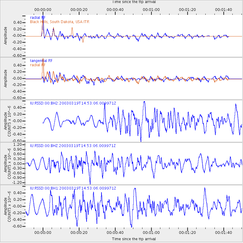
RSSD Black Hills, South Dakota, USA - Earthquake Result Viewer
*The percent match for this event was below the threshold and hence no stack was calculated.
| Earthquake location: |
Off East Coast Of Kamchatka |
| Earthquake latitude/longitude: |
52.2/160.7 |
| Earthquake time(UTC): |
2003/03/19 (078) 14:43:36 GMT |
| Earthquake Depth: |
33 km |
| Earthquake Magnitude: |
5.6 MB, 5.6 MW |
| Earthquake Catalog/Contributor: |
NEIC PDE/NEIC PDE-M |
|
| Network: |
IU Global Seismograph Network (GSN - IRIS/USGS) |
| Station: |
RSSD Black Hills, South Dakota, USA |
| Lat/Lon: |
44.12 N/104.04 W |
| Elevation: |
2060 m |
|
| Distance: |
59.6 deg |
| Az: |
56.27 deg |
| Baz: |
314.715 deg |
| Ray Param: |
$rayparam |
*The percent match for this event was below the threshold and hence was not used in the summary stack. |
|
| Radial Match: |
65.919716 % |
| Radial Bump: |
352 |
| Transverse Match: |
50.752052 % |
| Transverse Bump: |
400 |
| SOD ConfigId: |
590571 |
| Insert Time: |
2013-09-25 01:33:35.402 +0000 |
| GWidth: |
2.5 |
| Max Bumps: |
400 |
| Tol: |
0.001 |
|
Signal To Noise
| Channel | StoN | STA | LTA |
| IU:RSSD:00:BHZ:20030319T14:53:06.009971Z | 2.985663 | 3.164126E-7 | 1.0597734E-7 |
| IU:RSSD:00:BH1:20030319T14:53:06.009971Z | 1.0369478 | 2.349424E-7 | 2.2657109E-7 |
| IU:RSSD:00:BH2:20030319T14:53:06.009971Z | 1.6626632 | 1.762606E-7 | 1.06011E-7 |
| Arrivals |
| Ps | |
| PpPs | |
| PsPs/PpSs | |


