You are here: Home > Network List > IU - Global Seismograph Network (GSN - IRIS/USGS) Stations List
> Station JOHN Johnston Island, USA > Earthquake Result Viewer
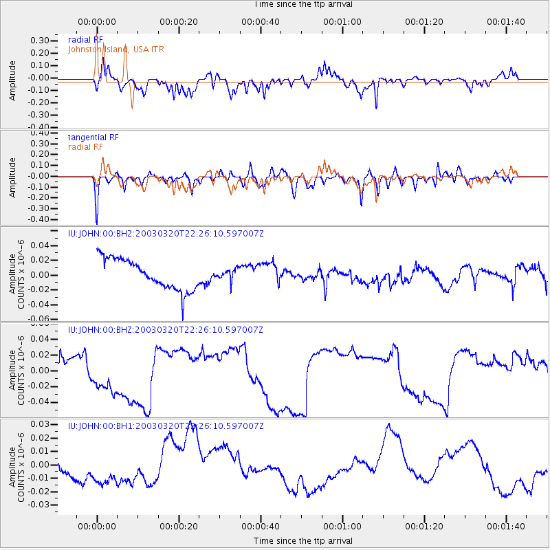
JOHN Johnston Island, USA - Earthquake Result Viewer
*The percent match for this event was below the threshold and hence no stack was calculated.
| Earthquake location: |
Southern Molucca Sea |
| Earthquake latitude/longitude: |
-0.2/125.2 |
| Earthquake time(UTC): |
2003/03/20 (079) 22:15:55 GMT |
| Earthquake Depth: |
33 km |
| Earthquake Magnitude: |
5.5 MW |
| Earthquake Catalog/Contributor: |
NEIC PDE/NEIC PDE-M |
|
| Network: |
IU Global Seismograph Network (GSN - IRIS/USGS) |
| Station: |
JOHN Johnston Island, USA |
| Lat/Lon: |
16.73 N/169.53 W |
| Elevation: |
2.0 m |
|
| Distance: |
66.5 deg |
| Az: |
71.718 deg |
| Baz: |
262.286 deg |
| Ray Param: |
$rayparam |
*The percent match for this event was below the threshold and hence was not used in the summary stack. |
|
| Radial Match: |
55.20948 % |
| Radial Bump: |
400 |
| Transverse Match: |
55.536263 % |
| Transverse Bump: |
400 |
| SOD ConfigId: |
590571 |
| Insert Time: |
2013-09-25 01:34:47.834 +0000 |
| GWidth: |
2.5 |
| Max Bumps: |
400 |
| Tol: |
0.001 |
|
Signal To Noise
| Channel | StoN | STA | LTA |
| IU:JOHN:00:BHZ:20030320T22:26:10.597007Z | 4.208111 | 2.6660667E-8 | 6.3355428E-9 |
| IU:JOHN:00:BH1:20030320T22:26:10.597007Z | 2.0243716 | 1.789874E-8 | 8.841629E-9 |
| IU:JOHN:00:BH2:20030320T22:26:10.597007Z | 0.36189532 | 7.423476E-9 | 2.051277E-8 |
| Arrivals |
| Ps | |
| PpPs | |
| PsPs/PpSs | |


