You are here: Home > Network List > II - Global Seismograph Network (GSN - IRIS/IDA) Stations List
> Station PALK Pallekele, Sri Lanka > Earthquake Result Viewer
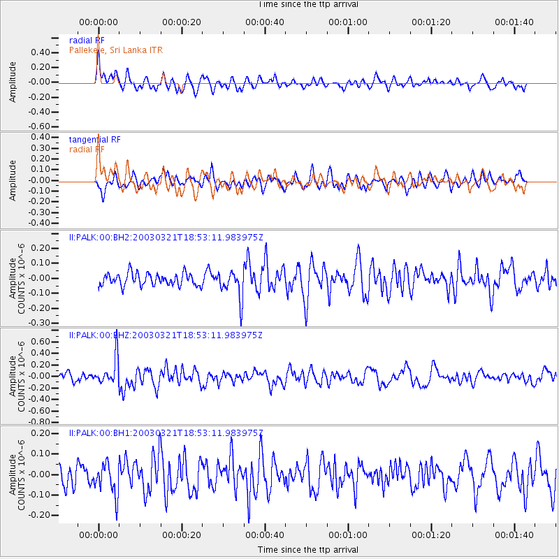
PALK Pallekele, Sri Lanka - Earthquake Result Viewer
*The percent match for this event was below the threshold and hence no stack was calculated.
| Earthquake location: |
Bonin Islands, Japan Region |
| Earthquake latitude/longitude: |
28.1/142.5 |
| Earthquake time(UTC): |
2003/03/21 (080) 18:43:27 GMT |
| Earthquake Depth: |
31 km |
| Earthquake Magnitude: |
5.5 MW |
| Earthquake Catalog/Contributor: |
NEIC PDE/NEIC PDE-M |
|
| Network: |
II Global Seismograph Network (GSN - IRIS/IDA) |
| Station: |
PALK Pallekele, Sri Lanka |
| Lat/Lon: |
7.27 N/80.70 E |
| Elevation: |
460 m |
|
| Distance: |
61.8 deg |
| Az: |
262.927 deg |
| Baz: |
62.102 deg |
| Ray Param: |
$rayparam |
*The percent match for this event was below the threshold and hence was not used in the summary stack. |
|
| Radial Match: |
69.107864 % |
| Radial Bump: |
400 |
| Transverse Match: |
58.830334 % |
| Transverse Bump: |
400 |
| SOD ConfigId: |
590571 |
| Insert Time: |
2013-09-25 01:35:11.139 +0000 |
| GWidth: |
2.5 |
| Max Bumps: |
400 |
| Tol: |
0.001 |
|
Signal To Noise
| Channel | StoN | STA | LTA |
| II:PALK:00:BHZ:20030321T18:53:11.983975Z | 3.2878475 | 2.4451862E-7 | 7.4370426E-8 |
| II:PALK:00:BH1:20030321T18:53:11.983975Z | 1.48094 | 7.791294E-8 | 5.2610464E-8 |
| II:PALK:00:BH2:20030321T18:53:11.983975Z | 2.411728 | 9.844384E-8 | 4.08188E-8 |
| Arrivals |
| Ps | |
| PpPs | |
| PsPs/PpSs | |


