You are here: Home > Network List > UW - Pacific Northwest Regional Seismic Network Stations List
> Station LEBA Lebam, WA, USA > Earthquake Result Viewer
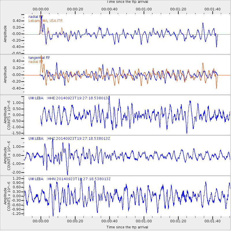
LEBA Lebam, WA, USA - Earthquake Result Viewer
*The percent match for this event was below the threshold and hence no stack was calculated.
| Earthquake location: |
Reykjanes Ridge |
| Earthquake latitude/longitude: |
53.1/-35.1 |
| Earthquake time(UTC): |
2014/09/23 (266) 19:18:25 GMT |
| Earthquake Depth: |
7.2 km |
| Earthquake Magnitude: |
5.4 MW |
| Earthquake Catalog/Contributor: |
ISC/ISC |
|
| Network: |
UW Pacific Northwest Regional Seismic Network |
| Station: |
LEBA Lebam, WA, USA |
| Lat/Lon: |
46.55 N/123.56 W |
| Elevation: |
73 m |
|
| Distance: |
53.9 deg |
| Az: |
301.4 deg |
| Baz: |
48.147 deg |
| Ray Param: |
$rayparam |
*The percent match for this event was below the threshold and hence was not used in the summary stack. |
|
| Radial Match: |
62.696922 % |
| Radial Bump: |
400 |
| Transverse Match: |
51.97994 % |
| Transverse Bump: |
400 |
| SOD ConfigId: |
3390531 |
| Insert Time: |
2019-04-14 04:51:42.679 +0000 |
| GWidth: |
2.5 |
| Max Bumps: |
400 |
| Tol: |
0.001 |
|
Signal To Noise
| Channel | StoN | STA | LTA |
| UW:LEBA: :HHZ:20140923T19:27:18.538013Z | 2.3930566 | 6.9288114E-7 | 2.8953812E-7 |
| UW:LEBA: :HHN:20140923T19:27:18.538013Z | 0.7302823 | 3.3101438E-7 | 4.5326905E-7 |
| UW:LEBA: :HHE:20140923T19:27:18.538013Z | 1.1488848 | 4.863568E-7 | 4.2332945E-7 |
| Arrivals |
| Ps | |
| PpPs | |
| PsPs/PpSs | |


