You are here: Home > Network List > IU - Global Seismograph Network (GSN - IRIS/USGS) Stations List
> Station RSSD Black Hills, South Dakota, USA > Earthquake Result Viewer
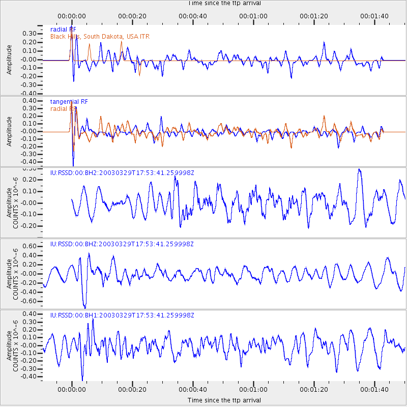
RSSD Black Hills, South Dakota, USA - Earthquake Result Viewer
*The percent match for this event was below the threshold and hence no stack was calculated.
| Earthquake location: |
Adriatic Sea |
| Earthquake latitude/longitude: |
43.1/15.5 |
| Earthquake time(UTC): |
2003/03/29 (088) 17:42:15 GMT |
| Earthquake Depth: |
10 km |
| Earthquake Magnitude: |
5.5 MB, 5.3 MS, 5.5 MW, 5.4 MW |
| Earthquake Catalog/Contributor: |
WHDF/NEIC |
|
| Network: |
IU Global Seismograph Network (GSN - IRIS/USGS) |
| Station: |
RSSD Black Hills, South Dakota, USA |
| Lat/Lon: |
44.12 N/104.04 W |
| Elevation: |
2060 m |
|
| Distance: |
77.7 deg |
| Az: |
320.095 deg |
| Baz: |
40.717 deg |
| Ray Param: |
$rayparam |
*The percent match for this event was below the threshold and hence was not used in the summary stack. |
|
| Radial Match: |
56.018486 % |
| Radial Bump: |
400 |
| Transverse Match: |
61.25507 % |
| Transverse Bump: |
400 |
| SOD ConfigId: |
590571 |
| Insert Time: |
2013-09-25 01:38:23.503 +0000 |
| GWidth: |
2.5 |
| Max Bumps: |
400 |
| Tol: |
0.001 |
|
Signal To Noise
| Channel | StoN | STA | LTA |
| IU:RSSD:00:BHZ:20030329T17:53:41.259998Z | 2.4137037 | 3.5827776E-7 | 1.4843485E-7 |
| IU:RSSD:00:BH1:20030329T17:53:41.259998Z | 2.1171725 | 1.5379996E-7 | 7.264404E-8 |
| IU:RSSD:00:BH2:20030329T17:53:41.259998Z | 1.4274075 | 1.0770859E-7 | 7.5457486E-8 |
| Arrivals |
| Ps | |
| PpPs | |
| PsPs/PpSs | |


