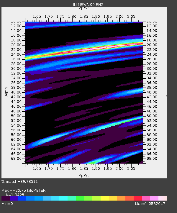
MBWA Marble Bar, Western Australia - Earthquake Result Viewer

Earthquake location: New Britain Region, P.N.G.
Earthquake latitude/longitude: -6.2/151.4
Earthquake time(UTC): 2003/03/31 (090) 01:06:53 GMT
Earthquake Depth: 47 km
Earthquake Magnitude: 6.0 MB, 6.1 MS, 6.2 MW, 6.1 MW
Earthquake Catalog/Contributor: WHDF/NEIC
Network: IU Global Seismograph Network (GSN - IRIS/USGS)
Station: MBWA Marble Bar, Western Australia
Lat/Lon: 21.16 S/119.73 E
Elevation: 190 m
Distance: 34.1 deg
Az: 241.003 deg
Baz: 68.698 deg
Ray Param: 0.077802084
Estimated Moho Depth: 20.75 km
Estimated Crust Vp/Vs: 1.94
Assumed Crust Vp: 6.464 km/s
Estimated Crust Vs: 3.327 km/s
Estimated Crust Poisson's Ratio: 0.32
Radial Match: 89.78511 %
Radial Bump: 388
Transverse Match: 63.565033 %
Transverse Bump: 400
SOD ConfigId: 590571
Insert Time: 2013-09-25 01:39:44.934 +0000
GWidth: 2.5
Max Bumps: 400
Tol: 0.001

Signal To Noise

ChannelStoNSTALTA
IU:MBWA:00:BHZ:20030331T01:13:02.960004Z10.5272742.0634948E-61.9601416E-7
IU:MBWA:00:BH1:20030331T01:13:02.960004Z7.60102221.3567396E-61.7849437E-7
IU:MBWA:00:BH2:20030331T01:13:02.960004Z1.89859573.608926E-71.9008398E-7
Arrivals
Ps3.2 SECOND
PpPs8.8 SECOND
PsPs/PpSs12 SECOND