You are here: Home > Network List > TA - USArray Transportable Network (new EarthScope stations) Stations List
> Station D49A Beulah Township, ON, CAN > Earthquake Result Viewer
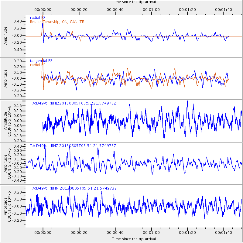
D49A Beulah Township, ON, CAN - Earthquake Result Viewer
*The percent match for this event was below the threshold and hence no stack was calculated.
| Earthquake location: |
Near Coast Of Northern Chile |
| Earthquake latitude/longitude: |
-20.2/-70.7 |
| Earthquake time(UTC): |
2013/08/05 (217) 05:40:56 GMT |
| Earthquake Depth: |
19 km |
| Earthquake Magnitude: |
5.5 MB |
| Earthquake Catalog/Contributor: |
NEIC PDE/NEIC PDE-W |
|
| Network: |
TA USArray Transportable Network (new EarthScope stations) |
| Station: |
D49A Beulah Township, ON, CAN |
| Lat/Lon: |
47.27 N/81.36 W |
| Elevation: |
416 m |
|
| Distance: |
67.8 deg |
| Az: |
352.193 deg |
| Baz: |
169.201 deg |
| Ray Param: |
$rayparam |
*The percent match for this event was below the threshold and hence was not used in the summary stack. |
|
| Radial Match: |
46.838066 % |
| Radial Bump: |
400 |
| Transverse Match: |
52.855293 % |
| Transverse Bump: |
400 |
| SOD ConfigId: |
589702 |
| Insert Time: |
2013-09-25 01:40:41.580 +0000 |
| GWidth: |
2.5 |
| Max Bumps: |
400 |
| Tol: |
0.001 |
|
Signal To Noise
| Channel | StoN | STA | LTA |
| TA:D49A: :BHZ:20130805T05:51:21.574973Z | 2.7212625 | 1.7378005E-7 | 6.386008E-8 |
| TA:D49A: :BHN:20130805T05:51:21.574973Z | 1.3435732 | 8.011577E-8 | 5.962888E-8 |
| TA:D49A: :BHE:20130805T05:51:21.574973Z | 1.0910566 | 6.206621E-8 | 5.688634E-8 |
| Arrivals |
| Ps | |
| PpPs | |
| PsPs/PpSs | |


