You are here: Home > Network List > TA - USArray Transportable Network (new EarthScope stations) Stations List
> Station J01E Myrtle Point, OR, USA > Earthquake Result Viewer
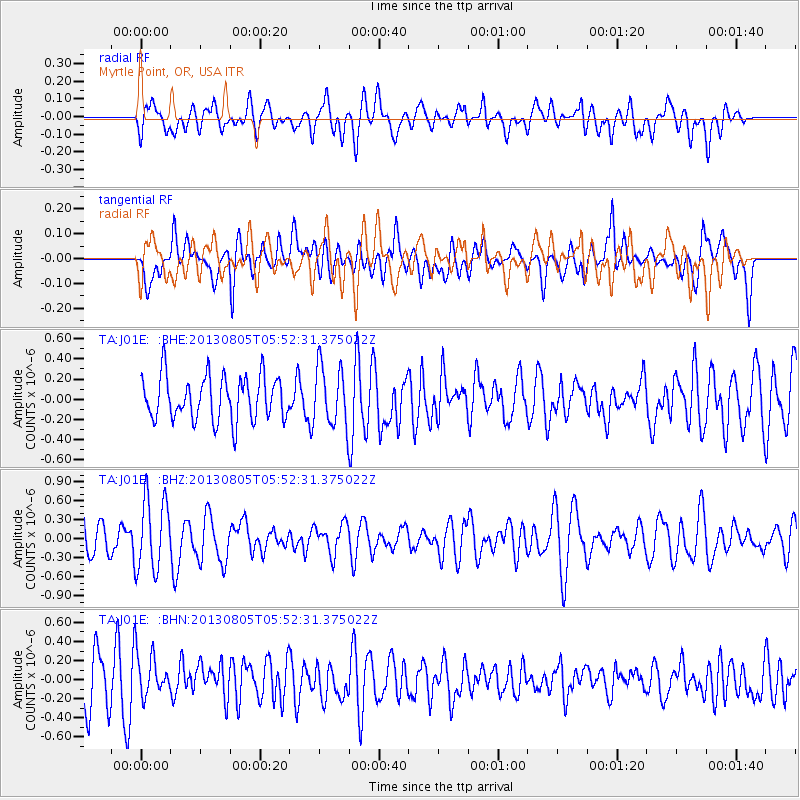
J01E Myrtle Point, OR, USA - Earthquake Result Viewer
*The percent match for this event was below the threshold and hence no stack was calculated.
| Earthquake location: |
Near Coast Of Northern Chile |
| Earthquake latitude/longitude: |
-20.2/-70.7 |
| Earthquake time(UTC): |
2013/08/05 (217) 05:40:56 GMT |
| Earthquake Depth: |
19 km |
| Earthquake Magnitude: |
5.5 MB |
| Earthquake Catalog/Contributor: |
NEIC PDE/NEIC PDE-W |
|
| Network: |
TA USArray Transportable Network (new EarthScope stations) |
| Station: |
J01E Myrtle Point, OR, USA |
| Lat/Lon: |
43.16 N/123.93 W |
| Elevation: |
128 m |
|
| Distance: |
79.8 deg |
| Az: |
323.449 deg |
| Baz: |
130.134 deg |
| Ray Param: |
$rayparam |
*The percent match for this event was below the threshold and hence was not used in the summary stack. |
|
| Radial Match: |
43.622276 % |
| Radial Bump: |
400 |
| Transverse Match: |
47.571987 % |
| Transverse Bump: |
400 |
| SOD ConfigId: |
589702 |
| Insert Time: |
2013-09-25 01:42:38.924 +0000 |
| GWidth: |
2.5 |
| Max Bumps: |
400 |
| Tol: |
0.001 |
|
Signal To Noise
| Channel | StoN | STA | LTA |
| TA:J01E: :BHZ:20130805T05:52:31.375022Z | 2.1525915 | 5.729005E-7 | 2.6614455E-7 |
| TA:J01E: :BHN:20130805T05:52:31.375022Z | 0.9751851 | 2.2084993E-7 | 2.2646975E-7 |
| TA:J01E: :BHE:20130805T05:52:31.375022Z | 1.3468859 | 2.935353E-7 | 2.1793628E-7 |
| Arrivals |
| Ps | |
| PpPs | |
| PsPs/PpSs | |


