You are here: Home > Network List > TA - USArray Transportable Network (new EarthScope stations) Stations List
> Station P56A Dayton Farm, Ripley, WV, USA > Earthquake Result Viewer
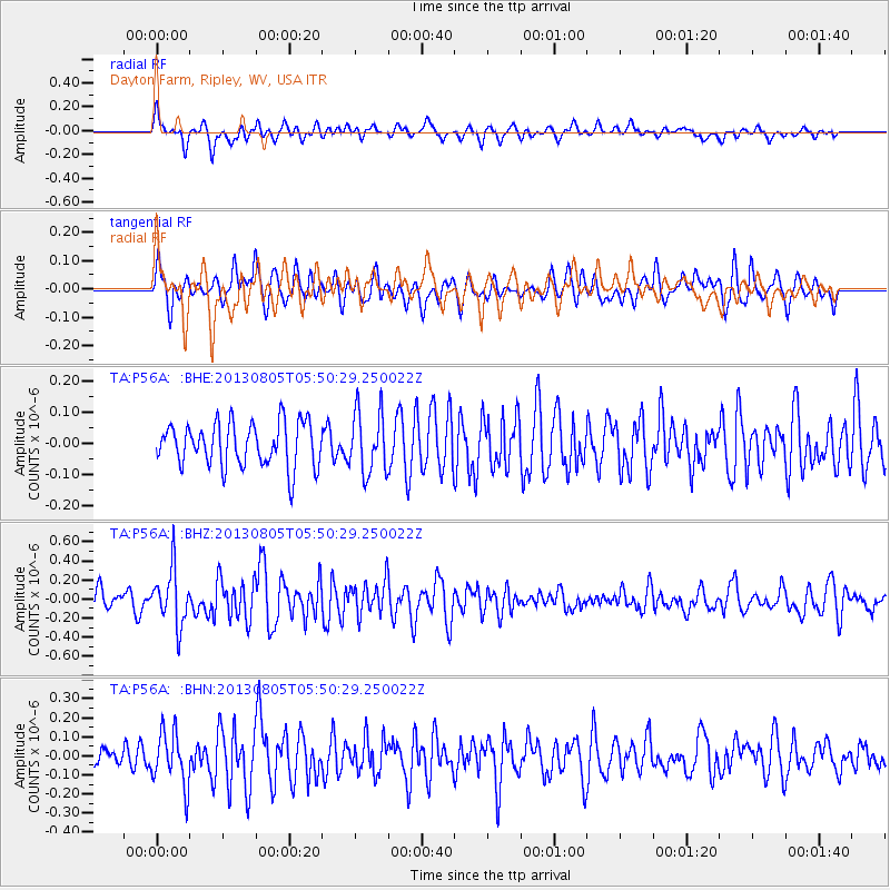
P56A Dayton Farm, Ripley, WV, USA - Earthquake Result Viewer
*The percent match for this event was below the threshold and hence no stack was calculated.
| Earthquake location: |
Near Coast Of Northern Chile |
| Earthquake latitude/longitude: |
-20.2/-70.7 |
| Earthquake time(UTC): |
2013/08/05 (217) 05:40:56 GMT |
| Earthquake Depth: |
19 km |
| Earthquake Magnitude: |
5.5 MB |
| Earthquake Catalog/Contributor: |
NEIC PDE/NEIC PDE-W |
|
| Network: |
TA USArray Transportable Network (new EarthScope stations) |
| Station: |
P56A Dayton Farm, Ripley, WV, USA |
| Lat/Lon: |
39.50 N/78.84 W |
| Elevation: |
249 m |
|
| Distance: |
59.9 deg |
| Az: |
352.734 deg |
| Baz: |
171.167 deg |
| Ray Param: |
$rayparam |
*The percent match for this event was below the threshold and hence was not used in the summary stack. |
|
| Radial Match: |
61.50122 % |
| Radial Bump: |
400 |
| Transverse Match: |
48.028442 % |
| Transverse Bump: |
400 |
| SOD ConfigId: |
589702 |
| Insert Time: |
2013-09-25 01:45:28.605 +0000 |
| GWidth: |
2.5 |
| Max Bumps: |
400 |
| Tol: |
0.001 |
|
Signal To Noise
| Channel | StoN | STA | LTA |
| TA:P56A: :BHZ:20130805T05:50:29.250022Z | 2.93541 | 2.868671E-7 | 9.7726414E-8 |
| TA:P56A: :BHN:20130805T05:50:29.250022Z | 2.3281145 | 1.3962921E-7 | 5.997523E-8 |
| TA:P56A: :BHE:20130805T05:50:29.250022Z | 1.4256462 | 9.989627E-8 | 7.007087E-8 |
| Arrivals |
| Ps | |
| PpPs | |
| PsPs/PpSs | |


