You are here: Home > Network List > TA - USArray Transportable Network (new EarthScope stations) Stations List
> Station T54A Tazewell, VA, USA > Earthquake Result Viewer
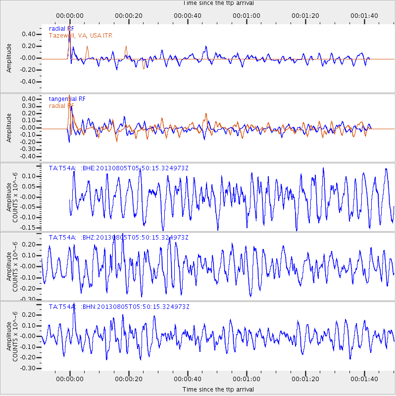
T54A Tazewell, VA, USA - Earthquake Result Viewer
*The percent match for this event was below the threshold and hence no stack was calculated.
| Earthquake location: |
Near Coast Of Northern Chile |
| Earthquake latitude/longitude: |
-20.2/-70.7 |
| Earthquake time(UTC): |
2013/08/05 (217) 05:40:56 GMT |
| Earthquake Depth: |
19 km |
| Earthquake Magnitude: |
5.5 MB |
| Earthquake Catalog/Contributor: |
NEIC PDE/NEIC PDE-W |
|
| Network: |
TA USArray Transportable Network (new EarthScope stations) |
| Station: |
T54A Tazewell, VA, USA |
| Lat/Lon: |
37.06 N/81.58 W |
| Elevation: |
852 m |
|
| Distance: |
57.8 deg |
| Az: |
349.742 deg |
| Baz: |
167.929 deg |
| Ray Param: |
$rayparam |
*The percent match for this event was below the threshold and hence was not used in the summary stack. |
|
| Radial Match: |
46.591763 % |
| Radial Bump: |
400 |
| Transverse Match: |
64.16056 % |
| Transverse Bump: |
400 |
| SOD ConfigId: |
589702 |
| Insert Time: |
2013-09-25 01:46:54.352 +0000 |
| GWidth: |
2.5 |
| Max Bumps: |
400 |
| Tol: |
0.001 |
|
Signal To Noise
| Channel | StoN | STA | LTA |
| TA:T54A: :BHZ:20130805T05:50:15.324973Z | 1.2649077 | 1.2652383E-7 | 1.0002613E-7 |
| TA:T54A: :BHN:20130805T05:50:15.324973Z | 2.5387986 | 1.11455535E-7 | 4.39009E-8 |
| TA:T54A: :BHE:20130805T05:50:15.324973Z | 1.2180153 | 7.520386E-8 | 6.1742945E-8 |
| Arrivals |
| Ps | |
| PpPs | |
| PsPs/PpSs | |


