You are here: Home > Network List > IU - Global Seismograph Network (GSN - IRIS/USGS) Stations List
> Station POHA Pohakuloa, Hawaii, USA > Earthquake Result Viewer
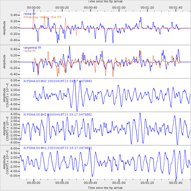
POHA Pohakuloa, Hawaii, USA - Earthquake Result Viewer
*The percent match for this event was below the threshold and hence no stack was calculated.
| Earthquake location: |
Tonga Islands |
| Earthquake latitude/longitude: |
-17.8/-173.9 |
| Earthquake time(UTC): |
2003/04/18 (108) 23:32:04 GMT |
| Earthquake Depth: |
33 km |
| Earthquake Magnitude: |
5.6 MW |
| Earthquake Catalog/Contributor: |
NEIC PDE/NEIC PDE-M |
|
| Network: |
IU Global Seismograph Network (GSN - IRIS/USGS) |
| Station: |
POHA Pohakuloa, Hawaii, USA |
| Lat/Lon: |
19.76 N/155.53 W |
| Elevation: |
1967 m |
|
| Distance: |
41.4 deg |
| Az: |
26.612 deg |
| Baz: |
206.951 deg |
| Ray Param: |
$rayparam |
*The percent match for this event was below the threshold and hence was not used in the summary stack. |
|
| Radial Match: |
61.3799 % |
| Radial Bump: |
327 |
| Transverse Match: |
58.363808 % |
| Transverse Bump: |
400 |
| SOD ConfigId: |
590571 |
| Insert Time: |
2013-09-25 01:48:31.330 +0000 |
| GWidth: |
2.5 |
| Max Bumps: |
400 |
| Tol: |
0.001 |
|
Signal To Noise
| Channel | StoN | STA | LTA |
| IU:POHA:00:BHZ:20030418T23:39:17.047988Z | 0.49831095 | 8.5832664E-7 | 1.7224719E-6 |
| IU:POHA:00:BH1:20030418T23:39:17.047988Z | 0.82268757 | 1.590749E-6 | 1.9336003E-6 |
| IU:POHA:00:BH2:20030418T23:39:17.047988Z | 3.3101778 | 4.167312E-6 | 1.258939E-6 |
| Arrivals |
| Ps | |
| PpPs | |
| PsPs/PpSs | |


