You are here: Home > Network List > IU - Global Seismograph Network (GSN - IRIS/USGS) Stations List
> Station RSSD Black Hills, South Dakota, USA > Earthquake Result Viewer
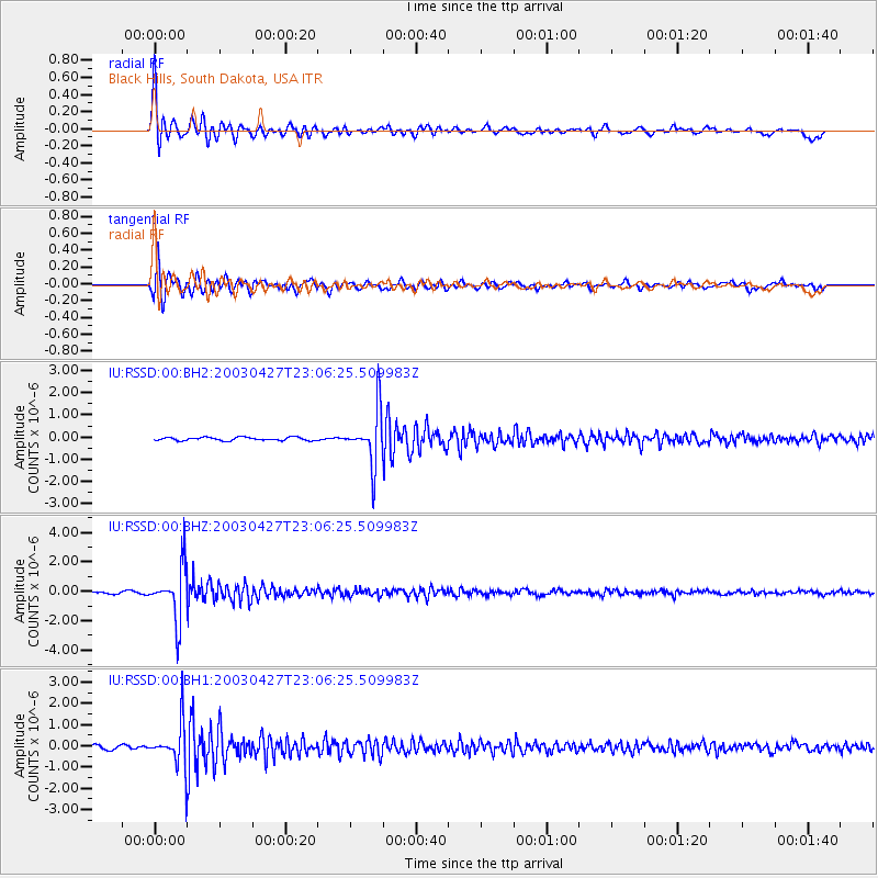
RSSD Black Hills, South Dakota, USA - Earthquake Result Viewer
*The percent match for this event was below the threshold and hence no stack was calculated.
| Earthquake location: |
Western Brazil |
| Earthquake latitude/longitude: |
-8.2/-71.6 |
| Earthquake time(UTC): |
2003/04/27 (117) 22:57:44 GMT |
| Earthquake Depth: |
560 km |
| Earthquake Magnitude: |
5.6 MB, 6.0 MW, 5.9 MW |
| Earthquake Catalog/Contributor: |
WHDF/NEIC |
|
| Network: |
IU Global Seismograph Network (GSN - IRIS/USGS) |
| Station: |
RSSD Black Hills, South Dakota, USA |
| Lat/Lon: |
44.12 N/104.04 W |
| Elevation: |
2060 m |
|
| Distance: |
59.8 deg |
| Az: |
333.437 deg |
| Baz: |
142.074 deg |
| Ray Param: |
$rayparam |
*The percent match for this event was below the threshold and hence was not used in the summary stack. |
|
| Radial Match: |
89.362144 % |
| Radial Bump: |
400 |
| Transverse Match: |
90.39046 % |
| Transverse Bump: |
400 |
| SOD ConfigId: |
590571 |
| Insert Time: |
2013-09-25 01:51:20.482 +0000 |
| GWidth: |
2.5 |
| Max Bumps: |
400 |
| Tol: |
0.001 |
|
Signal To Noise
| Channel | StoN | STA | LTA |
| IU:RSSD:00:BHZ:20030427T23:06:25.509983Z | 25.136574 | 1.7911401E-6 | 7.125634E-8 |
| IU:RSSD:00:BH1:20030427T23:06:25.509983Z | 12.630396 | 1.0304362E-6 | 8.158384E-8 |
| IU:RSSD:00:BH2:20030427T23:06:25.509983Z | 16.226797 | 1.2082983E-6 | 7.446313E-8 |
| Arrivals |
| Ps | |
| PpPs | |
| PsPs/PpSs | |


