You are here: Home > Network List > CN - Canadian National Seismograph Network Stations List
> Station ULM LAC DU BONNET, MB, CANADA > Earthquake Result Viewer
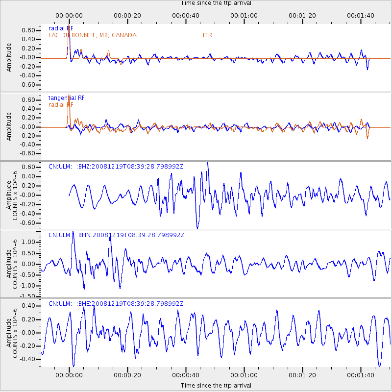
ULM LAC DU BONNET, MB, CANADA - Earthquake Result Viewer
*The percent match for this event was below the threshold and hence no stack was calculated.
| Earthquake location: |
Northern Mid-Atlantic Ridge |
| Earthquake latitude/longitude: |
47.0/-27.3 |
| Earthquake time(UTC): |
2008/12/19 (354) 08:31:51 GMT |
| Earthquake Depth: |
2.0 km |
| Earthquake Magnitude: |
5.8 MB, 5.6 MS, 5.9 MW, 5.8 MW |
| Earthquake Catalog/Contributor: |
WHDF/NEIC |
|
| Network: |
CN Canadian National Seismograph Network |
| Station: |
ULM LAC DU BONNET, MB, CANADA |
| Lat/Lon: |
50.25 N/95.87 W |
| Elevation: |
251 m |
|
| Distance: |
44.0 deg |
| Az: |
300.631 deg |
| Baz: |
66.546 deg |
| Ray Param: |
$rayparam |
*The percent match for this event was below the threshold and hence was not used in the summary stack. |
|
| Radial Match: |
77.75119 % |
| Radial Bump: |
400 |
| Transverse Match: |
61.2098 % |
| Transverse Bump: |
389 |
| SOD ConfigId: |
2658 |
| Insert Time: |
2010-02-27 07:37:14.294 +0000 |
| GWidth: |
2.5 |
| Max Bumps: |
400 |
| Tol: |
0.001 |
|
Signal To Noise
| Channel | StoN | STA | LTA |
| CN:ULM: :BHN:20081219T08:39:28.798992Z | 3.8582397 | 6.103771E-7 | 1.5820095E-7 |
| CN:ULM: :BHE:20081219T08:39:28.798992Z | 1.7064456 | 2.4966292E-7 | 1.4630582E-7 |
| CN:ULM: :BHZ:20081219T08:39:28.798992Z | 1.5986738 | 2.2787484E-7 | 1.4253992E-7 |
| Arrivals |
| Ps | |
| PpPs | |
| PsPs/PpSs | |


