You are here: Home > Network List > IU - Global Seismograph Network (GSN - IRIS/USGS) Stations List
> Station JOHN Johnston Island, USA > Earthquake Result Viewer
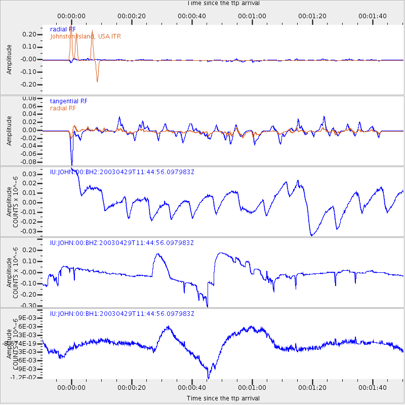
JOHN Johnston Island, USA - Earthquake Result Viewer
*The percent match for this event was below the threshold and hence no stack was calculated.
| Earthquake location: |
Southwest Of Sumatra, Indonesia |
| Earthquake latitude/longitude: |
-7.0/103.7 |
| Earthquake time(UTC): |
2003/04/29 (119) 11:32:33 GMT |
| Earthquake Depth: |
10 km |
| Earthquake Magnitude: |
5.5 MW |
| Earthquake Catalog/Contributor: |
NEIC PDE/NEIC PDE-M |
|
| Network: |
IU Global Seismograph Network (GSN - IRIS/USGS) |
| Station: |
JOHN Johnston Island, USA |
| Lat/Lon: |
16.73 N/169.53 W |
| Elevation: |
2.0 m |
|
| Distance: |
88.9 deg |
| Az: |
73.105 deg |
| Baz: |
262.386 deg |
| Ray Param: |
$rayparam |
*The percent match for this event was below the threshold and hence was not used in the summary stack. |
|
| Radial Match: |
54.769325 % |
| Radial Bump: |
376 |
| Transverse Match: |
65.77244 % |
| Transverse Bump: |
326 |
| SOD ConfigId: |
590571 |
| Insert Time: |
2013-09-25 01:51:59.976 +0000 |
| GWidth: |
2.5 |
| Max Bumps: |
400 |
| Tol: |
0.001 |
|
Signal To Noise
| Channel | StoN | STA | LTA |
| IU:JOHN:00:BHZ:20030429T11:44:56.097983Z | 1.2711152 | 6.6637696E-8 | 5.2424593E-8 |
| IU:JOHN:00:BH1:20030429T11:44:56.097983Z | 0.5581712 | 1.878556E-9 | 3.3655554E-9 |
| IU:JOHN:00:BH2:20030429T11:44:56.097983Z | 1.2290905 | 1.4560963E-8 | 1.1846942E-8 |
| Arrivals |
| Ps | |
| PpPs | |
| PsPs/PpSs | |


