You are here: Home > Network List > WY - Yellowstone Wyoming Seismic Network Stations List
> Station YHH Holmes Hill, YNP, WY, USA > Earthquake Result Viewer
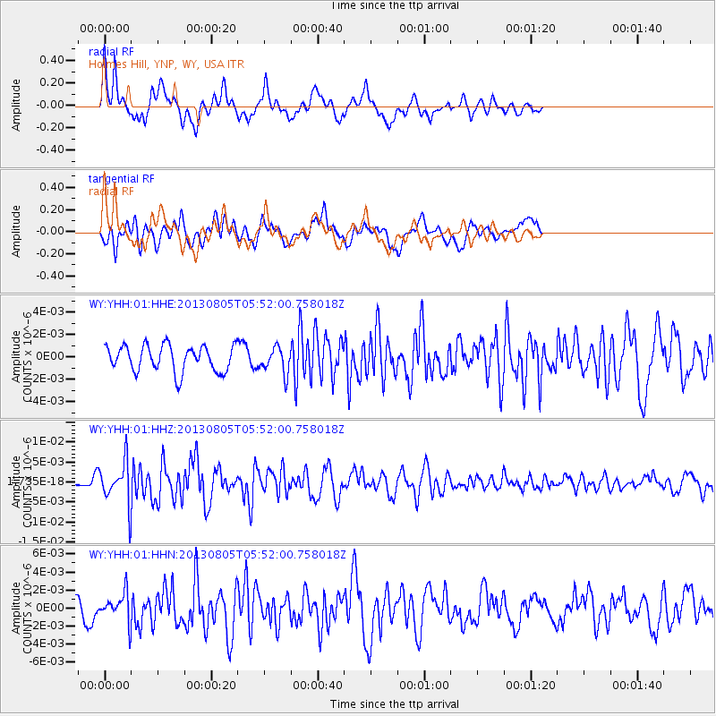
YHH Holmes Hill, YNP, WY, USA - Earthquake Result Viewer
*The percent match for this event was below the threshold and hence no stack was calculated.
| Earthquake location: |
Near Coast Of Northern Chile |
| Earthquake latitude/longitude: |
-20.2/-70.7 |
| Earthquake time(UTC): |
2013/08/05 (217) 05:40:56 GMT |
| Earthquake Depth: |
19 km |
| Earthquake Magnitude: |
5.5 MB |
| Earthquake Catalog/Contributor: |
NEIC PDE/NEIC PDE-W |
|
| Network: |
WY Yellowstone Wyoming Seismic Network |
| Station: |
YHH Holmes Hill, YNP, WY, USA |
| Lat/Lon: |
44.79 N/110.85 W |
| Elevation: |
2717 m |
|
| Distance: |
74.3 deg |
| Az: |
331.522 deg |
| Baz: |
141.023 deg |
| Ray Param: |
$rayparam |
*The percent match for this event was below the threshold and hence was not used in the summary stack. |
|
| Radial Match: |
77.89856 % |
| Radial Bump: |
400 |
| Transverse Match: |
69.11947 % |
| Transverse Bump: |
400 |
| SOD ConfigId: |
589702 |
| Insert Time: |
2013-09-25 01:52:38.119 +0000 |
| GWidth: |
2.5 |
| Max Bumps: |
400 |
| Tol: |
0.001 |
|
Signal To Noise
| Channel | StoN | STA | LTA |
| WY:YHH:01:HHZ:20130805T05:52:00.758018Z | 3.4683974 | 4.941102E-9 | 1.4246068E-9 |
| WY:YHH:01:HHN:20130805T05:52:00.758018Z | 1.4508216 | 1.5275686E-9 | 1.052899E-9 |
| WY:YHH:01:HHE:20130805T05:52:00.758018Z | 1.0098056 | 1.1709266E-9 | 1.1595566E-9 |
| Arrivals |
| Ps | |
| PpPs | |
| PsPs/PpSs | |


