You are here: Home > Network List > IU - Global Seismograph Network (GSN - IRIS/USGS) Stations List
> Station JOHN Johnston Island, USA > Earthquake Result Viewer
JOHN Johnston Island, USA - Earthquake Result Viewer

| Earthquake location: |
Flores Sea |
| Earthquake latitude/longitude: |
-7.2/122.7 |
| Earthquake time(UTC): |
2003/05/01 (121) 04:02:05 GMT |
| Earthquake Depth: |
573 km |
| Earthquake Magnitude: |
5.6 MB, 5.6 MW |
| Earthquake Catalog/Contributor: |
NEIC PDE/NEIC PDE-M |
|
| Network: |
IU Global Seismograph Network (GSN - IRIS/USGS) |
| Station: |
JOHN Johnston Island, USA |
| Lat/Lon: |
16.73 N/169.53 W |
| Elevation: |
2.0 m |
|
| Distance: |
71.1 deg |
| Az: |
69.645 deg |
| Baz: |
256.129 deg |
| Ray Param: |
0.052605603 |
| Estimated Moho Depth: |
64.0 km |
| Estimated Crust Vp/Vs: |
1.63 |
| Assumed Crust Vp: |
4.24 km/s |
| Estimated Crust Vs: |
2.601 km/s |
| Estimated Crust Poisson's Ratio: |
0.20 |
|
| Radial Match: |
93.22403 % |
| Radial Bump: |
297 |
| Transverse Match: |
78.54945 % |
| Transverse Bump: |
358 |
| SOD ConfigId: |
590571 |
| Insert Time: |
2013-09-25 01:53:46.744 +0000 |
| GWidth: |
2.5 |
| Max Bumps: |
400 |
| Tol: |
0.001 |
|
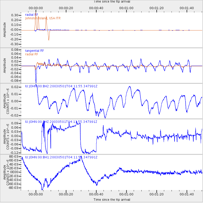
Signal To Noise
| Channel | StoN | STA | LTA |
| IU:JOHN:00:BHZ:20030501T04:11:55.347991Z | 1.4847966 | 1.02780966E-7 | 6.9222246E-8 |
| IU:JOHN:00:BH1:20030501T04:11:55.347991Z | 2.6103494 | 6.8843313E-9 | 2.6373217E-9 |
| IU:JOHN:00:BH2:20030501T04:11:55.347991Z | 1.3667405 | 1.1966001E-8 | 8.755137E-9 |
| Arrivals |
| Ps | 9.7 SECOND |
| PpPs | 39 SECOND |
| PsPs/PpSs | 49 SECOND |


