You are here: Home > Network List > IU - Global Seismograph Network (GSN - IRIS/USGS) Stations List
> Station JOHN Johnston Island, USA > Earthquake Result Viewer
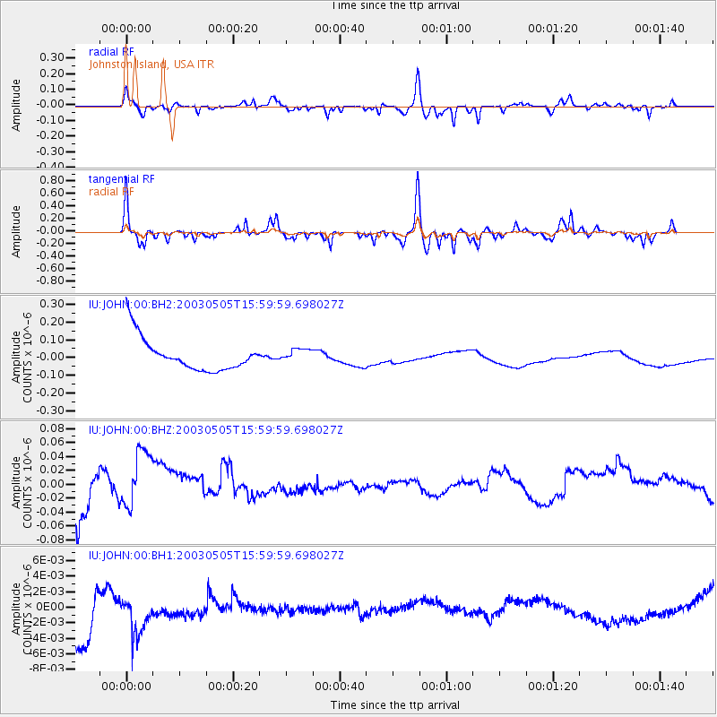
JOHN Johnston Island, USA - Earthquake Result Viewer
*The percent match for this event was below the threshold and hence no stack was calculated.
| Earthquake location: |
Halmahera, Indonesia |
| Earthquake latitude/longitude: |
0.2/127.4 |
| Earthquake time(UTC): |
2003/05/05 (125) 15:50:08 GMT |
| Earthquake Depth: |
124 km |
| Earthquake Magnitude: |
5.9 MB, 6.4 MW, 6.4 MW |
| Earthquake Catalog/Contributor: |
WHDF/NEIC |
|
| Network: |
IU Global Seismograph Network (GSN - IRIS/USGS) |
| Station: |
JOHN Johnston Island, USA |
| Lat/Lon: |
16.73 N/169.53 W |
| Elevation: |
2.0 m |
|
| Distance: |
64.3 deg |
| Az: |
71.586 deg |
| Baz: |
261.971 deg |
| Ray Param: |
$rayparam |
*The percent match for this event was below the threshold and hence was not used in the summary stack. |
|
| Radial Match: |
51.748505 % |
| Radial Bump: |
327 |
| Transverse Match: |
59.57714 % |
| Transverse Bump: |
337 |
| SOD ConfigId: |
590571 |
| Insert Time: |
2013-09-25 01:57:17.785 +0000 |
| GWidth: |
2.5 |
| Max Bumps: |
400 |
| Tol: |
0.001 |
|
Signal To Noise
| Channel | StoN | STA | LTA |
| IU:JOHN:00:BHZ:20030505T15:59:59.698027Z | 1.1304111 | 4.2893895E-8 | 3.7945394E-8 |
| IU:JOHN:00:BH1:20030505T15:59:59.698027Z | 0.6990781 | 5.9515135E-9 | 8.513374E-9 |
| IU:JOHN:00:BH2:20030505T15:59:59.698027Z | 0.4097158 | 3.7828098E-8 | 9.232765E-8 |
| Arrivals |
| Ps | |
| PpPs | |
| PsPs/PpSs | |


