You are here: Home > Network List > IU - Global Seismograph Network (GSN - IRIS/USGS) Stations List
> Station RSSD Black Hills, South Dakota, USA > Earthquake Result Viewer
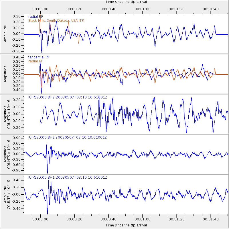
RSSD Black Hills, South Dakota, USA - Earthquake Result Viewer
*The percent match for this event was below the threshold and hence no stack was calculated.
| Earthquake location: |
Mongolia |
| Earthquake latitude/longitude: |
48.5/89.6 |
| Earthquake time(UTC): |
2003/05/07 (127) 02:58:00 GMT |
| Earthquake Depth: |
33 km |
| Earthquake Magnitude: |
5.6 MB |
| Earthquake Catalog/Contributor: |
NEIC PDE/NEIC PDE-M |
|
| Network: |
IU Global Seismograph Network (GSN - IRIS/USGS) |
| Station: |
RSSD Black Hills, South Dakota, USA |
| Lat/Lon: |
44.12 N/104.04 W |
| Elevation: |
2060 m |
|
| Distance: |
87.0 deg |
| Az: |
9.77 deg |
| Baz: |
350.99 deg |
| Ray Param: |
$rayparam |
*The percent match for this event was below the threshold and hence was not used in the summary stack. |
|
| Radial Match: |
60.584923 % |
| Radial Bump: |
400 |
| Transverse Match: |
61.4302 % |
| Transverse Bump: |
400 |
| SOD ConfigId: |
590571 |
| Insert Time: |
2013-09-25 01:58:22.512 +0000 |
| GWidth: |
2.5 |
| Max Bumps: |
400 |
| Tol: |
0.001 |
|
Signal To Noise
| Channel | StoN | STA | LTA |
| IU:RSSD:00:BHZ:20030507T03:10:10.61001Z | 3.3795712 | 2.7641406E-7 | 8.1789686E-8 |
| IU:RSSD:00:BH1:20030507T03:10:10.61001Z | 1.4691882 | 1.8239403E-7 | 1.2414613E-7 |
| IU:RSSD:00:BH2:20030507T03:10:10.61001Z | 1.2101576 | 9.261727E-8 | 7.6533226E-8 |
| Arrivals |
| Ps | |
| PpPs | |
| PsPs/PpSs | |


