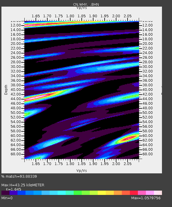
WHY Whitehorse, YT - Earthquake Result Viewer

Earthquake location: New Britain Region, P.N.G.
Earthquake latitude/longitude: -5.9/151.0
Earthquake time(UTC): 2006/10/17 (290) 01:25:12 GMT
Earthquake Depth: 32 km
Earthquake Magnitude: 6.4 MB, 6.9 MS, 6.7 MW, 6.6 MW
Earthquake Catalog/Contributor: WHDF/NEIC
Network: CN Canadian National Seismograph Network
Station: WHY Whitehorse, YT
Lat/Lon: 60.66 N/134.88 W
Elevation: 1292 m
Distance: 87.4 deg
Az: 28.309 deg
Baz: 253.317 deg
Ray Param: 0.043312054
Estimated Moho Depth: 43.25 km
Estimated Crust Vp/Vs: 1.64
Assumed Crust Vp: 6.419 km/s
Estimated Crust Vs: 3.902 km/s
Estimated Crust Poisson's Ratio: 0.21
Radial Match: 93.88339 %
Radial Bump: 400
Transverse Match: 85.51393 %
Transverse Bump: 400
SOD ConfigId: 2564
Insert Time: 2010-02-27 07:37:25.204 +0000
GWidth: 2.5
Max Bumps: 400
Tol: 0.001

Signal To Noise

ChannelStoNSTALTA
CN:WHY: :BHN:20061017T01:37:24.974019Z1.77438523.2563153E-71.8351794E-7
CN:WHY: :BHE:20061017T01:37:24.974019Z10.8555781.1997323E-61.1051759E-7
CN:WHY: :BHZ:20061017T01:37:24.974019Z32.0450173.833368E-61.1962445E-7
Arrivals
Ps4.5 SECOND
PpPs17 SECOND
PsPs/PpSs22 SECOND