You are here: Home > Network List > IU - Global Seismograph Network (GSN - IRIS/USGS) Stations List
> Station POHA Pohakuloa, Hawaii, USA > Earthquake Result Viewer
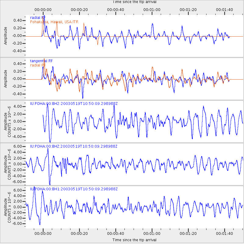
POHA Pohakuloa, Hawaii, USA - Earthquake Result Viewer
*The percent match for this event was below the threshold and hence no stack was calculated.
| Earthquake location: |
Fiji Islands Region |
| Earthquake latitude/longitude: |
-18.0/-178.7 |
| Earthquake time(UTC): |
2003/05/19 (139) 10:43:22 GMT |
| Earthquake Depth: |
564 km |
| Earthquake Magnitude: |
5.7 MB, 6.0 MW, 6.0 MW |
| Earthquake Catalog/Contributor: |
WHDF/NEIC |
|
| Network: |
IU Global Seismograph Network (GSN - IRIS/USGS) |
| Station: |
POHA Pohakuloa, Hawaii, USA |
| Lat/Lon: |
19.76 N/155.53 W |
| Elevation: |
1967 m |
|
| Distance: |
43.9 deg |
| Az: |
32.259 deg |
| Baz: |
212.627 deg |
| Ray Param: |
$rayparam |
*The percent match for this event was below the threshold and hence was not used in the summary stack. |
|
| Radial Match: |
63.492252 % |
| Radial Bump: |
400 |
| Transverse Match: |
48.016014 % |
| Transverse Bump: |
400 |
| SOD ConfigId: |
590571 |
| Insert Time: |
2013-09-25 02:04:24.314 +0000 |
| GWidth: |
2.5 |
| Max Bumps: |
400 |
| Tol: |
0.001 |
|
Signal To Noise
| Channel | StoN | STA | LTA |
| IU:POHA:00:BHZ:20030519T10:50:09.298988Z | 2.90763 | 3.397724E-6 | 1.1685545E-6 |
| IU:POHA:00:BH1:20030519T10:50:09.298988Z | 1.3484006 | 2.6432856E-6 | 1.960312E-6 |
| IU:POHA:00:BH2:20030519T10:50:09.298988Z | 0.8194117 | 1.7068932E-6 | 2.0830716E-6 |
| Arrivals |
| Ps | |
| PpPs | |
| PsPs/PpSs | |


