You are here: Home > Network List > IU - Global Seismograph Network (GSN - IRIS/USGS) Stations List
> Station JOHN Johnston Island, USA > Earthquake Result Viewer
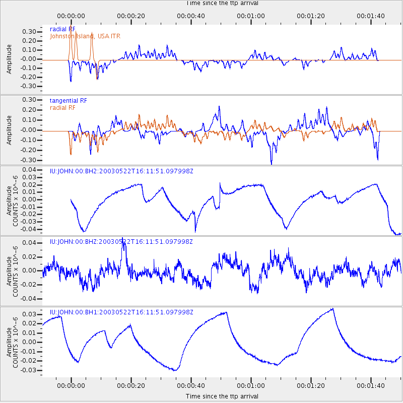
JOHN Johnston Island, USA - Earthquake Result Viewer
*The percent match for this event was below the threshold and hence no stack was calculated.
| Earthquake location: |
Minahassa Peninsula, Sulawesi |
| Earthquake latitude/longitude: |
0.2/123.9 |
| Earthquake time(UTC): |
2003/05/22 (142) 16:01:42 GMT |
| Earthquake Depth: |
156 km |
| Earthquake Magnitude: |
5.5 MW |
| Earthquake Catalog/Contributor: |
NEIC PDE/NEIC PDE-M |
|
| Network: |
IU Global Seismograph Network (GSN - IRIS/USGS) |
| Station: |
JOHN Johnston Island, USA |
| Lat/Lon: |
16.73 N/169.53 W |
| Elevation: |
2.0 m |
|
| Distance: |
67.5 deg |
| Az: |
72.026 deg |
| Baz: |
263.072 deg |
| Ray Param: |
$rayparam |
*The percent match for this event was below the threshold and hence was not used in the summary stack. |
|
| Radial Match: |
31.53232 % |
| Radial Bump: |
252 |
| Transverse Match: |
40.736958 % |
| Transverse Bump: |
283 |
| SOD ConfigId: |
590571 |
| Insert Time: |
2013-09-25 02:06:28.437 +0000 |
| GWidth: |
2.5 |
| Max Bumps: |
400 |
| Tol: |
0.001 |
|
Signal To Noise
| Channel | StoN | STA | LTA |
| IU:JOHN:00:BHZ:20030522T16:11:51.097998Z | 1.3111986 | 1.574117E-8 | 1.20051755E-8 |
| IU:JOHN:00:BH1:20030522T16:11:51.097998Z | 0.44800106 | 7.9836076E-9 | 1.7820511E-8 |
| IU:JOHN:00:BH2:20030522T16:11:51.097998Z | 0.5812804 | 1.1283786E-8 | 1.9411951E-8 |
| Arrivals |
| Ps | |
| PpPs | |
| PsPs/PpSs | |


