You are here: Home > Network List > IU - Global Seismograph Network (GSN - IRIS/USGS) Stations List
> Station RSSD Black Hills, South Dakota, USA > Earthquake Result Viewer
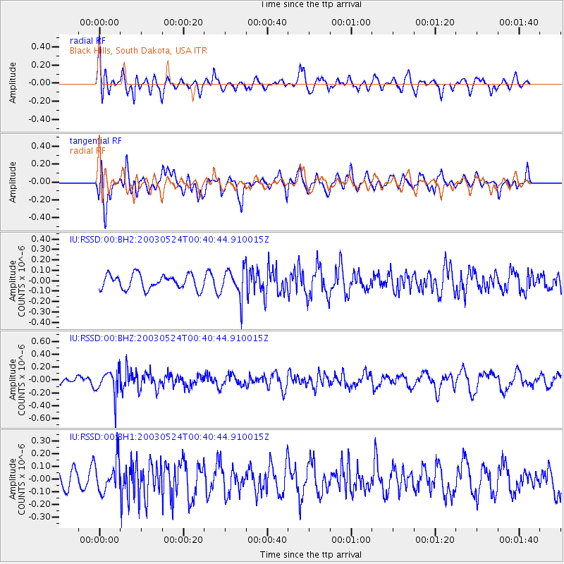
RSSD Black Hills, South Dakota, USA - Earthquake Result Viewer
*The percent match for this event was below the threshold and hence no stack was calculated.
| Earthquake location: |
Central Peru |
| Earthquake latitude/longitude: |
-14.7/-71.5 |
| Earthquake time(UTC): |
2003/05/24 (144) 00:30:47 GMT |
| Earthquake Depth: |
144 km |
| Earthquake Magnitude: |
5.1 MB, 5.6 MW |
| Earthquake Catalog/Contributor: |
WHDF/NEIC |
|
| Network: |
IU Global Seismograph Network (GSN - IRIS/USGS) |
| Station: |
RSSD Black Hills, South Dakota, USA |
| Lat/Lon: |
44.12 N/104.04 W |
| Elevation: |
2060 m |
|
| Distance: |
65.6 deg |
| Az: |
334.837 deg |
| Baz: |
145.154 deg |
| Ray Param: |
$rayparam |
*The percent match for this event was below the threshold and hence was not used in the summary stack. |
|
| Radial Match: |
59.78282 % |
| Radial Bump: |
400 |
| Transverse Match: |
54.908882 % |
| Transverse Bump: |
400 |
| SOD ConfigId: |
590571 |
| Insert Time: |
2013-09-25 02:08:29.104 +0000 |
| GWidth: |
2.5 |
| Max Bumps: |
400 |
| Tol: |
0.001 |
|
Signal To Noise
| Channel | StoN | STA | LTA |
| IU:RSSD:00:BHZ:20030524T00:40:44.910015Z | 2.3536224 | 1.954949E-7 | 8.306129E-8 |
| IU:RSSD:00:BH1:20030524T00:40:44.910015Z | 1.3778825 | 1.2274886E-7 | 8.908514E-8 |
| IU:RSSD:00:BH2:20030524T00:40:44.910015Z | 2.0135067 | 1.393741E-7 | 6.921958E-8 |
| Arrivals |
| Ps | |
| PpPs | |
| PsPs/PpSs | |


