You are here: Home > Network List > IU - Global Seismograph Network (GSN - IRIS/USGS) Stations List
> Station POHA Pohakuloa, Hawaii, USA > Earthquake Result Viewer
POHA Pohakuloa, Hawaii, USA - Earthquake Result Viewer
| Earthquake location: |
Near East Coast Of Honshu, Japan |
| Earthquake latitude/longitude: |
38.8/141.6 |
| Earthquake time(UTC): |
2003/05/26 (146) 09:24:33 GMT |
| Earthquake Depth: |
68 km |
| Earthquake Magnitude: |
6.7 MB, 7.0 MW, 7.0 MW |
| Earthquake Catalog/Contributor: |
WHDF/NEIC |
|
| Network: |
IU Global Seismograph Network (GSN - IRIS/USGS) |
| Station: |
POHA Pohakuloa, Hawaii, USA |
| Lat/Lon: |
19.76 N/155.53 W |
| Elevation: |
1967 m |
|
| Distance: |
57.0 deg |
| Az: |
90.386 deg |
| Baz: |
303.999 deg |
| Ray Param: |
0.0636067 |
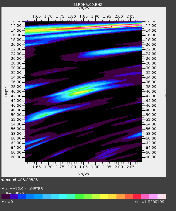
| Estimated Moho Depth: |
12.0 km |
| Estimated Crust Vp/Vs: |
1.97 |
| Assumed Crust Vp: |
5.195 km/s |
| Estimated Crust Vs: |
2.64 km/s |
| Estimated Crust Poisson's Ratio: |
0.33 |
|
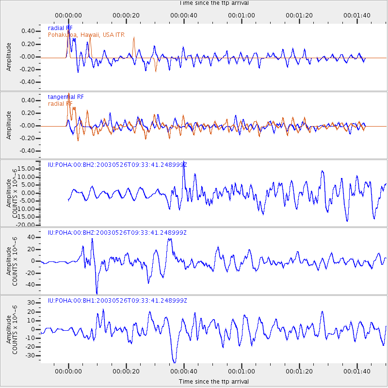
| Radial Match: |
85.30535 % |
| Radial Bump: |
400 |
| Transverse Match: |
79.17292 % |
| Transverse Bump: |
400 |
| SOD ConfigId: |
590571 |
| Insert Time: |
2013-09-25 02:09:13.205 +0000 |
| GWidth: |
2.5 |
| Max Bumps: |
400 |
| Tol: |
0.001 |
|
Signal To Noise
| Channel | StoN | STA | LTA |
| IU:POHA:00:BHZ:20030526T09:33:41.248999Z | 3.0953846 | 6.363199E-6 | 2.0557056E-6 |
| IU:POHA:00:BH1:20030526T09:33:41.248999Z | 1.3631206 | 2.652657E-6 | 1.9460178E-6 |
| IU:POHA:00:BH2:20030526T09:33:41.248999Z | 1.1300161 | 2.45846E-6 | 2.175597E-6 |
| Arrivals |
| Ps | 2.3 SECOND |
| PpPs | 6.7 SECOND |
| PsPs/PpSs | 9.0 SECOND |


