You are here: Home > Network List > IU - Global Seismograph Network (GSN - IRIS/USGS) Stations List
> Station RSSD Black Hills, South Dakota, USA > Earthquake Result Viewer
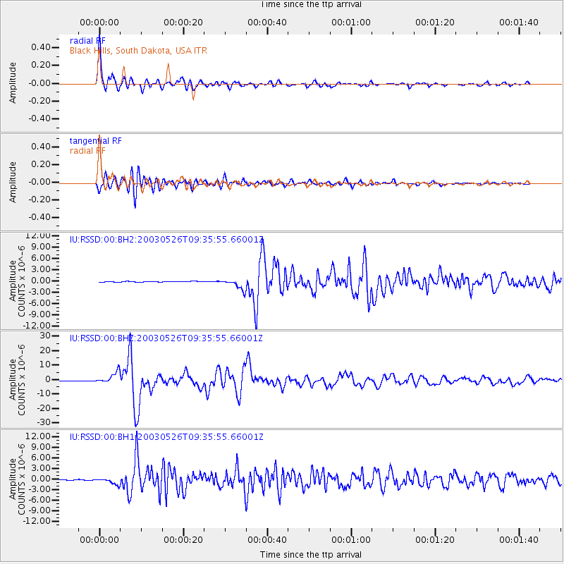
RSSD Black Hills, South Dakota, USA - Earthquake Result Viewer
| Earthquake location: |
Near East Coast Of Honshu, Japan |
| Earthquake latitude/longitude: |
38.8/141.6 |
| Earthquake time(UTC): |
2003/05/26 (146) 09:24:33 GMT |
| Earthquake Depth: |
68 km |
| Earthquake Magnitude: |
6.7 MB, 7.0 MW, 7.0 MW |
| Earthquake Catalog/Contributor: |
WHDF/NEIC |
|
| Network: |
IU Global Seismograph Network (GSN - IRIS/USGS) |
| Station: |
RSSD Black Hills, South Dakota, USA |
| Lat/Lon: |
44.12 N/104.04 W |
| Elevation: |
2060 m |
|
| Distance: |
78.4 deg |
| Az: |
42.035 deg |
| Baz: |
313.451 deg |
| Ray Param: |
0.049529467 |
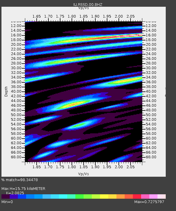
| Estimated Moho Depth: |
15.75 km |
| Estimated Crust Vp/Vs: |
2.08 |
| Assumed Crust Vp: |
6.242 km/s |
| Estimated Crust Vs: |
2.997 km/s |
| Estimated Crust Poisson's Ratio: |
0.35 |
|
| Radial Match: |
98.34478 % |
| Radial Bump: |
381 |
| Transverse Match: |
93.095604 % |
| Transverse Bump: |
400 |
| SOD ConfigId: |
590571 |
| Insert Time: |
2013-09-25 02:09:17.936 +0000 |
| GWidth: |
2.5 |
| Max Bumps: |
400 |
| Tol: |
0.001 |
|
Signal To Noise
| Channel | StoN | STA | LTA |
| IU:RSSD:00:BHZ:20030526T09:35:55.66001Z | 41.924484 | 4.2260194E-6 | 1.0080075E-7 |
| IU:RSSD:00:BH1:20030526T09:35:55.66001Z | 10.72188 | 9.195797E-7 | 8.5766644E-8 |
| IU:RSSD:00:BH2:20030526T09:35:55.66001Z | 16.564886 | 1.4779141E-6 | 8.921969E-8 |
| Arrivals |
| Ps | 2.8 SECOND |
| PpPs | 7.6 SECOND |
| PsPs/PpSs | 10 SECOND |


