You are here: Home > Network List > II - Global Seismograph Network (GSN - IRIS/IDA) Stations List
> Station PALK Pallekele, Sri Lanka > Earthquake Result Viewer
PALK Pallekele, Sri Lanka - Earthquake Result Viewer
| Earthquake location: |
Halmahera, Indonesia |
| Earthquake latitude/longitude: |
2.4/128.9 |
| Earthquake time(UTC): |
2003/05/26 (146) 19:23:27 GMT |
| Earthquake Depth: |
31 km |
| Earthquake Magnitude: |
6.5 MB, 7.1 MS, 7.0 MW, 6.8 MW |
| Earthquake Catalog/Contributor: |
WHDF/NEIC |
|
| Network: |
II Global Seismograph Network (GSN - IRIS/IDA) |
| Station: |
PALK Pallekele, Sri Lanka |
| Lat/Lon: |
7.27 N/80.70 E |
| Elevation: |
460 m |
|
| Distance: |
48.2 deg |
| Az: |
277.604 deg |
| Baz: |
93.334 deg |
| Ray Param: |
0.06945063 |
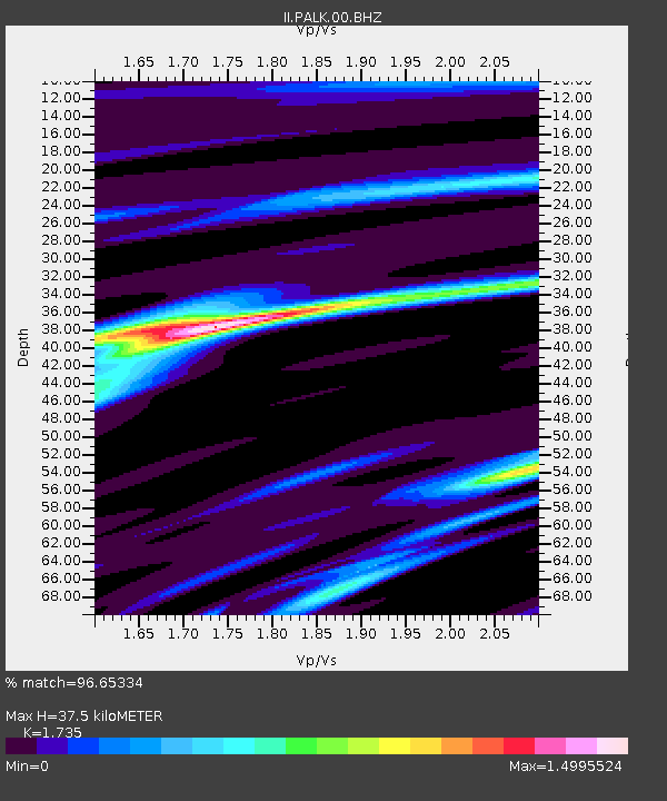
| Estimated Moho Depth: |
37.5 km |
| Estimated Crust Vp/Vs: |
1.74 |
| Assumed Crust Vp: |
6.545 km/s |
| Estimated Crust Vs: |
3.773 km/s |
| Estimated Crust Poisson's Ratio: |
0.25 |
|
| Radial Match: |
96.65334 % |
| Radial Bump: |
304 |
| Transverse Match: |
90.67459 % |
| Transverse Bump: |
400 |
| SOD ConfigId: |
590571 |
| Insert Time: |
2013-09-25 02:10:03.314 +0000 |
| GWidth: |
2.5 |
| Max Bumps: |
400 |
| Tol: |
0.001 |
|
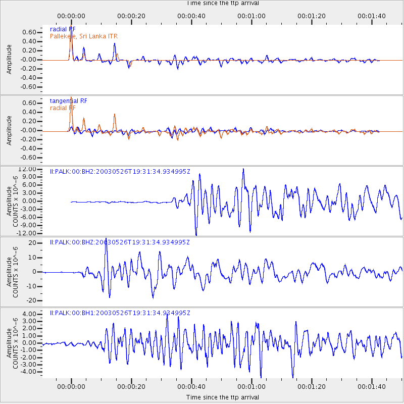
Signal To Noise
| Channel | StoN | STA | LTA |
| II:PALK:00:BHZ:20030526T19:31:34.934995Z | 6.1157694 | 1.0267436E-6 | 1.6788461E-7 |
| II:PALK:00:BH1:20030526T19:31:34.934995Z | 1.6549296 | 1.4318766E-7 | 8.65219E-8 |
| II:PALK:00:BH2:20030526T19:31:34.934995Z | 4.6548243 | 6.142513E-7 | 1.3196015E-7 |
| Arrivals |
| Ps | 4.5 SECOND |
| PpPs | 15 SECOND |
| PsPs/PpSs | 19 SECOND |


