You are here: Home > Network List > II - Global Seismograph Network (GSN - IRIS/IDA) Stations List
> Station COCO West Island, Cocos (Keeling) Islands > Earthquake Result Viewer
COCO West Island, Cocos (Keeling) Islands - Earthquake Result Viewer
| Earthquake location: |
Mindanao, Philippines |
| Earthquake latitude/longitude: |
6.8/123.7 |
| Earthquake time(UTC): |
2003/05/26 (146) 23:13:29 GMT |
| Earthquake Depth: |
566 km |
| Earthquake Magnitude: |
6.2 MB, 6.8 MW, 6.8 MW |
| Earthquake Catalog/Contributor: |
WHDF/NEIC |
|
| Network: |
II Global Seismograph Network (GSN - IRIS/IDA) |
| Station: |
COCO West Island, Cocos (Keeling) Islands |
| Lat/Lon: |
12.19 S/96.83 E |
| Elevation: |
1.0 m |
|
| Distance: |
32.7 deg |
| Az: |
234.92 deg |
| Baz: |
56.226 deg |
| Ray Param: |
0.07588068 |
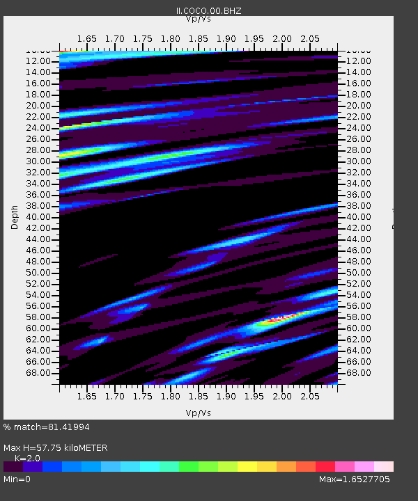
| Estimated Moho Depth: |
57.75 km |
| Estimated Crust Vp/Vs: |
2.00 |
| Assumed Crust Vp: |
4.24 km/s |
| Estimated Crust Vs: |
2.12 km/s |
| Estimated Crust Poisson's Ratio: |
0.33 |
|
| Radial Match: |
81.41994 % |
| Radial Bump: |
400 |
| Transverse Match: |
65.41364 % |
| Transverse Bump: |
400 |
| SOD ConfigId: |
590571 |
| Insert Time: |
2013-09-25 02:10:32.828 +0000 |
| GWidth: |
2.5 |
| Max Bumps: |
400 |
| Tol: |
0.001 |
|
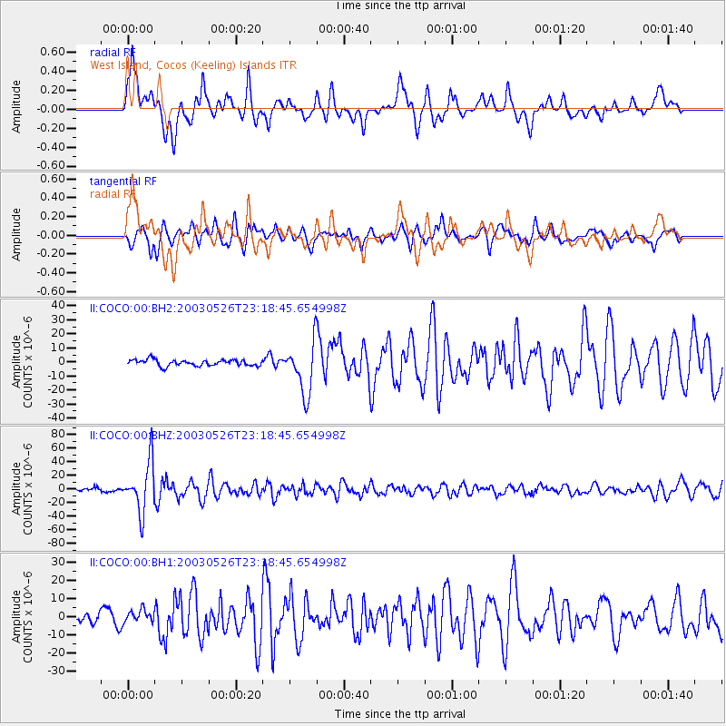
Signal To Noise
| Channel | StoN | STA | LTA |
| II:COCO:00:BHZ:20030526T23:18:45.654998Z | 18.90114 | 3.7179518E-5 | 1.9670517E-6 |
| II:COCO:00:BH1:20030526T23:18:45.654998Z | 1.080469 | 3.3795802E-6 | 3.1278828E-6 |
| II:COCO:00:BH2:20030526T23:18:45.654998Z | 8.509284 | 1.8532346E-5 | 2.1778972E-6 |
| Arrivals |
| Ps | 14 SECOND |
| PpPs | 40 SECOND |
| PsPs/PpSs | 54 SECOND |


