You are here: Home > Network List > II - Global Seismograph Network (GSN - IRIS/IDA) Stations List
> Station PALK Pallekele, Sri Lanka > Earthquake Result Viewer
PALK Pallekele, Sri Lanka - Earthquake Result Viewer

| Earthquake location: |
Mindanao, Philippines |
| Earthquake latitude/longitude: |
6.8/123.7 |
| Earthquake time(UTC): |
2003/05/26 (146) 23:13:29 GMT |
| Earthquake Depth: |
566 km |
| Earthquake Magnitude: |
6.2 MB, 6.8 MW, 6.8 MW |
| Earthquake Catalog/Contributor: |
WHDF/NEIC |
|
| Network: |
II Global Seismograph Network (GSN - IRIS/IDA) |
| Station: |
PALK Pallekele, Sri Lanka |
| Lat/Lon: |
7.27 N/80.70 E |
| Elevation: |
460 m |
|
| Distance: |
42.7 deg |
| Az: |
273.387 deg |
| Baz: |
87.913 deg |
| Ray Param: |
0.07018949 |
| Estimated Moho Depth: |
36.0 km |
| Estimated Crust Vp/Vs: |
1.81 |
| Assumed Crust Vp: |
6.545 km/s |
| Estimated Crust Vs: |
3.626 km/s |
| Estimated Crust Poisson's Ratio: |
0.28 |
|
| Radial Match: |
90.54716 % |
| Radial Bump: |
338 |
| Transverse Match: |
74.59543 % |
| Transverse Bump: |
400 |
| SOD ConfigId: |
590571 |
| Insert Time: |
2013-09-25 02:10:37.834 +0000 |
| GWidth: |
2.5 |
| Max Bumps: |
400 |
| Tol: |
0.001 |
|
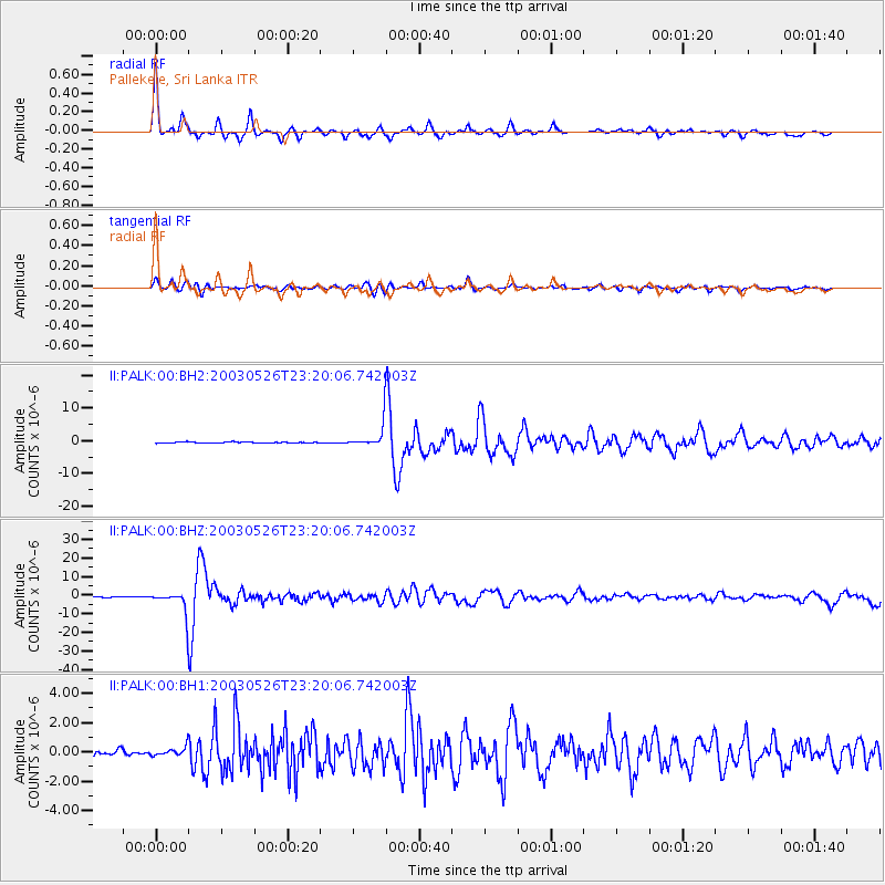
Signal To Noise
| Channel | StoN | STA | LTA |
| II:PALK:00:BHZ:20030526T23:20:06.742003Z | 28.416803 | 6.427994E-6 | 2.2620397E-7 |
| II:PALK:00:BH1:20030526T23:20:06.742003Z | 2.2147052 | 3.1887825E-7 | 1.4398225E-7 |
| II:PALK:00:BH2:20030526T23:20:06.742003Z | 20.43957 | 3.4844998E-6 | 1.7047813E-7 |
| Arrivals |
| Ps | 4.7 SECOND |
| PpPs | 14 SECOND |
| PsPs/PpSs | 19 SECOND |


