You are here: Home > Network List > IU - Global Seismograph Network (GSN - IRIS/USGS) Stations List
> Station MIDW Midway Island, USA > Earthquake Result Viewer
MIDW Midway Island, USA - Earthquake Result Viewer
| Earthquake location: |
Mindanao, Philippines |
| Earthquake latitude/longitude: |
6.8/123.7 |
| Earthquake time(UTC): |
2003/05/26 (146) 23:13:29 GMT |
| Earthquake Depth: |
566 km |
| Earthquake Magnitude: |
6.2 MB, 6.8 MW, 6.8 MW |
| Earthquake Catalog/Contributor: |
WHDF/NEIC |
|
| Network: |
IU Global Seismograph Network (GSN - IRIS/USGS) |
| Station: |
MIDW Midway Island, USA |
| Lat/Lon: |
28.22 N/177.37 W |
| Elevation: |
18 m |
|
| Distance: |
59.5 deg |
| Az: |
61.299 deg |
| Baz: |
260.791 deg |
| Ray Param: |
0.059885446 |
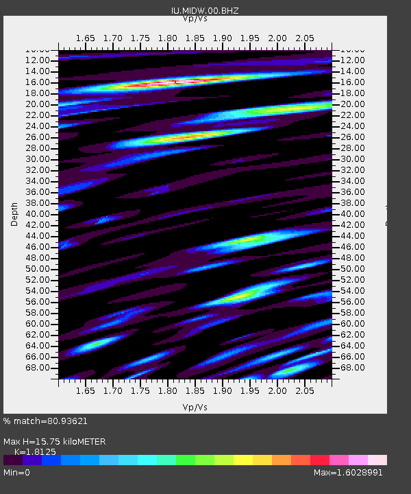
| Estimated Moho Depth: |
15.75 km |
| Estimated Crust Vp/Vs: |
1.81 |
| Assumed Crust Vp: |
4.24 km/s |
| Estimated Crust Vs: |
2.339 km/s |
| Estimated Crust Poisson's Ratio: |
0.28 |
|
| Radial Match: |
80.93621 % |
| Radial Bump: |
400 |
| Transverse Match: |
65.23724 % |
| Transverse Bump: |
400 |
| SOD ConfigId: |
590571 |
| Insert Time: |
2013-09-25 02:10:42.977 +0000 |
| GWidth: |
2.5 |
| Max Bumps: |
400 |
| Tol: |
0.001 |
|

Signal To Noise
| Channel | StoN | STA | LTA |
| IU:MIDW:00:BHZ:20030526T23:22:08.185027Z | 10.19725 | 1.51610275E-5 | 1.4867761E-6 |
| IU:MIDW:00:BH1:20030526T23:22:08.185027Z | 2.3480985 | 5.048134E-6 | 2.1498818E-6 |
| IU:MIDW:00:BH2:20030526T23:22:08.185027Z | 4.778447 | 8.380105E-6 | 1.7537299E-6 |
| Arrivals |
| Ps | 3.1 SECOND |
| PpPs | 10 SECOND |
| PsPs/PpSs | 13 SECOND |


