You are here: Home > Network List > IU - Global Seismograph Network (GSN - IRIS/USGS) Stations List
> Station RSSD Black Hills, South Dakota, USA > Earthquake Result Viewer
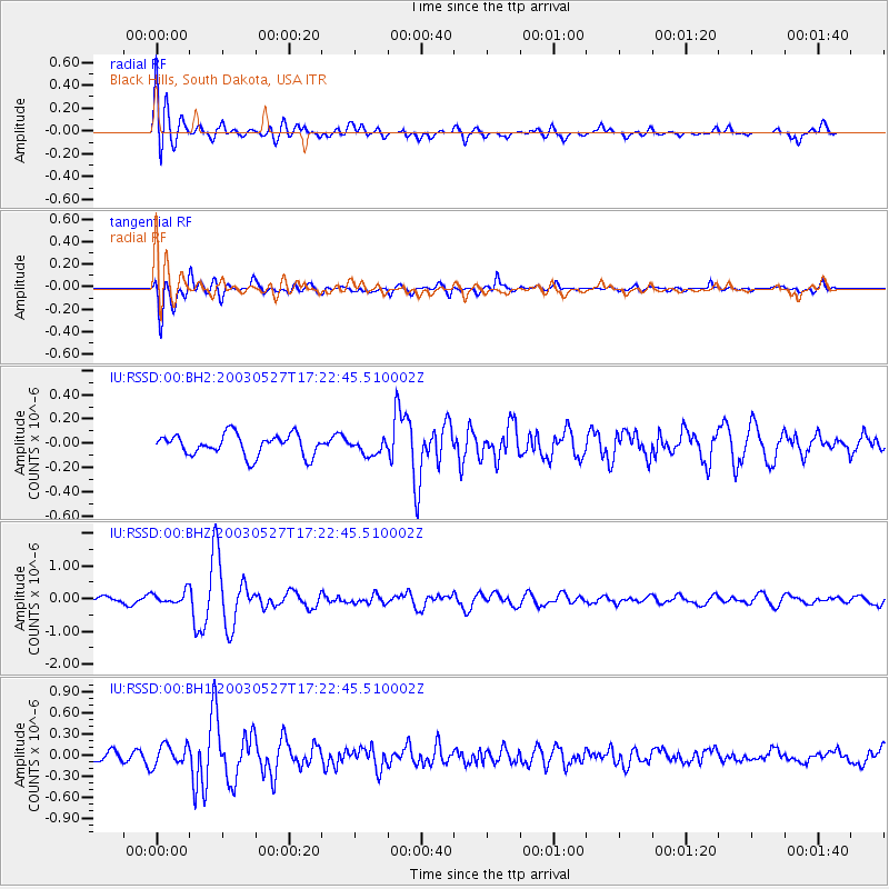
RSSD Black Hills, South Dakota, USA - Earthquake Result Viewer
*The percent match for this event was below the threshold and hence no stack was calculated.
| Earthquake location: |
Northern Algeria |
| Earthquake latitude/longitude: |
36.9/3.6 |
| Earthquake time(UTC): |
2003/05/27 (147) 17:11:28 GMT |
| Earthquake Depth: |
8.0 km |
| Earthquake Magnitude: |
5.5 MB, 5.5 MS, 5.8 MW, 5.7 MW |
| Earthquake Catalog/Contributor: |
WHDF/NEIC |
|
| Network: |
IU Global Seismograph Network (GSN - IRIS/USGS) |
| Station: |
RSSD Black Hills, South Dakota, USA |
| Lat/Lon: |
44.12 N/104.04 W |
| Elevation: |
2060 m |
|
| Distance: |
76.1 deg |
| Az: |
314.992 deg |
| Baz: |
51.882 deg |
| Ray Param: |
$rayparam |
*The percent match for this event was below the threshold and hence was not used in the summary stack. |
|
| Radial Match: |
72.58772 % |
| Radial Bump: |
400 |
| Transverse Match: |
80.673935 % |
| Transverse Bump: |
400 |
| SOD ConfigId: |
590571 |
| Insert Time: |
2013-09-25 02:12:24.551 +0000 |
| GWidth: |
2.5 |
| Max Bumps: |
400 |
| Tol: |
0.001 |
|
Signal To Noise
| Channel | StoN | STA | LTA |
| IU:RSSD:00:BHZ:20030527T17:22:45.510002Z | 2.030576 | 1.8771152E-7 | 9.24425E-8 |
| IU:RSSD:00:BH1:20030527T17:22:45.510002Z | 1.5603216 | 1.4914052E-7 | 9.55832E-8 |
| IU:RSSD:00:BH2:20030527T17:22:45.510002Z | 0.7366341 | 6.461266E-8 | 8.771337E-8 |
| Arrivals |
| Ps | |
| PpPs | |
| PsPs/PpSs | |


