You are here: Home > Network List > IU - Global Seismograph Network (GSN - IRIS/USGS) Stations List
> Station RSSD Black Hills, South Dakota, USA > Earthquake Result Viewer
RSSD Black Hills, South Dakota, USA - Earthquake Result Viewer
*The percent match for this event was below the threshold and hence no stack was calculated.
| Earthquake location: |
Near Coast Of Peru |
| Earthquake latitude/longitude: |
-12.4/-77.2 |
| Earthquake time(UTC): |
2003/05/28 (148) 21:26:47 GMT |
| Earthquake Depth: |
43 km |
| Earthquake Magnitude: |
5.4 MB, 4.8 MS, 5.6 MW, 5.4 MW |
| Earthquake Catalog/Contributor: |
WHDF/NEIC |
|
| Network: |
IU Global Seismograph Network (GSN - IRIS/USGS) |
| Station: |
RSSD Black Hills, South Dakota, USA |
| Lat/Lon: |
44.12 N/104.04 W |
| Elevation: |
2060 m |
|
| Distance: |
61.3 deg |
| Az: |
338.228 deg |
| Baz: |
149.79 deg |
| Ray Param: |
$rayparam |
*The percent match for this event was below the threshold and hence was not used in the summary stack. |
|
| Radial Match: |
65.98094 % |
| Radial Bump: |
400 |
| Transverse Match: |
59.4872 % |
| Transverse Bump: |
400 |
| SOD ConfigId: |
590571 |
| Insert Time: |
2013-09-25 02:13:15.677 +0000 |
| GWidth: |
2.5 |
| Max Bumps: |
400 |
| Tol: |
0.001 |
|
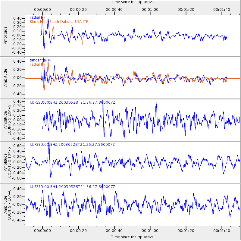
Signal To Noise
| Channel | StoN | STA | LTA |
| IU:RSSD:00:BHZ:20030528T21:36:27.860007Z | 2.45048 | 2.8249838E-7 | 1.1528287E-7 |
| IU:RSSD:00:BH1:20030528T21:36:27.860007Z | 1.6470604 | 1.970119E-7 | 1.1961426E-7 |
| IU:RSSD:00:BH2:20030528T21:36:27.860007Z | 1.5442028 | 1.6635445E-7 | 1.07728376E-7 |
| Arrivals |
| Ps | |
| PpPs | |
| PsPs/PpSs | |


