You are here: Home > Network List > IU - Global Seismograph Network (GSN - IRIS/USGS) Stations List
> Station RSSD Black Hills, South Dakota, USA > Earthquake Result Viewer
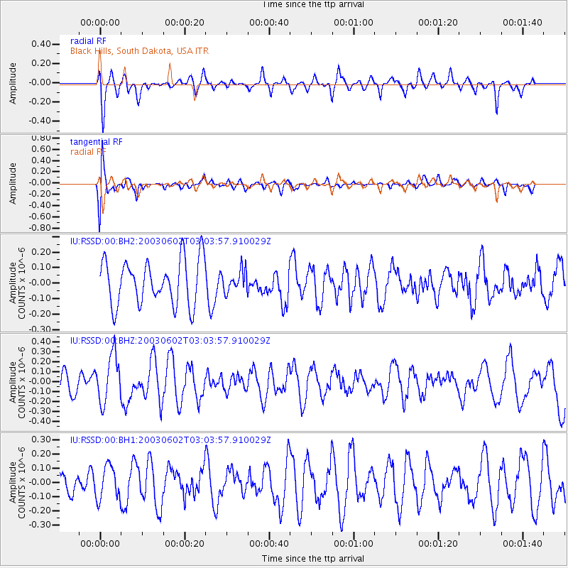
RSSD Black Hills, South Dakota, USA - Earthquake Result Viewer
*The percent match for this event was below the threshold and hence no stack was calculated.
| Earthquake location: |
Near Coast Of Central Chile |
| Earthquake latitude/longitude: |
-33.0/-72.0 |
| Earthquake time(UTC): |
2003/06/02 (153) 02:52:11 GMT |
| Earthquake Depth: |
33 km |
| Earthquake Magnitude: |
5.5 MW, 5.5 ML |
| Earthquake Catalog/Contributor: |
NEIC PDE/NEIC PDE-M |
|
| Network: |
IU Global Seismograph Network (GSN - IRIS/USGS) |
| Station: |
RSSD Black Hills, South Dakota, USA |
| Lat/Lon: |
44.12 N/104.04 W |
| Elevation: |
2060 m |
|
| Distance: |
82.1 deg |
| Az: |
337.292 deg |
| Baz: |
153.212 deg |
| Ray Param: |
$rayparam |
*The percent match for this event was below the threshold and hence was not used in the summary stack. |
|
| Radial Match: |
70.62676 % |
| Radial Bump: |
400 |
| Transverse Match: |
58.186546 % |
| Transverse Bump: |
400 |
| SOD ConfigId: |
590571 |
| Insert Time: |
2013-09-25 02:14:56.421 +0000 |
| GWidth: |
2.5 |
| Max Bumps: |
400 |
| Tol: |
0.001 |
|
Signal To Noise
| Channel | StoN | STA | LTA |
| IU:RSSD:00:BHZ:20030602T03:03:57.910029Z | 1.8972739 | 2.440711E-7 | 1.2864305E-7 |
| IU:RSSD:00:BH1:20030602T03:03:57.910029Z | 0.8546165 | 1.2058989E-7 | 1.4110408E-7 |
| IU:RSSD:00:BH2:20030602T03:03:57.910029Z | 0.4747426 | 6.9139055E-8 | 1.4563481E-7 |
| Arrivals |
| Ps | |
| PpPs | |
| PsPs/PpSs | |


